USArray Catches a Basin and Range Province Earthquake
The Wells earthquake happened in the middle of USArray, an array of seismographs that is sweeping across the United States.


This 7 km deep magnitude 6 earthquake caused a lot of shaking in Wells, Nevada.
Learn about USArray
The USArray's seismographs are
closely spaced in a grid pattern with unprecedented density,
clearly showing how seismic waves travel outward from an earthquake's epicenter in
all directions.

What is the Movie Showing?
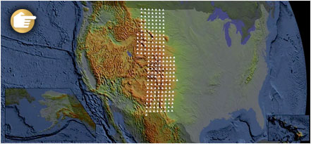
Each circle on the map represents one seismograph. The color of each circle represents the amplitude, or height, of the earthquake wave detected. Blue represents downward ground motion, red represents upward ground motion, and darker colors indicate larger amplitudes. This is the actual data from the instruments.
Question 1:
Each dot on the picture represents a seismograph. Why are there so many seismographs in the western US?
Question 2:
Why is the ground moving so far away from the earthquake in the movie?
Question 3:
Why did a moderate (magnitude 6) earthquake cause so much damage?