Earthquake Maps
Event maps are available for the past 24 hours, 7 days, 30 days,
and 1 year.
Event Maps | View
Make map options
Google Map Service (GMS) 
The Google Map generator creates maps based on IRIS DMC metadata
holdings. Requesting data directly from the IRIS DMC Oracle database
the GMS creates dynamic station maps that can be panned and
zoomed. The GMS can produce network, single station or arbitrary
station set maps. Users can generate a kml file to view
stations in Google Earth.
GMS | Learn
more
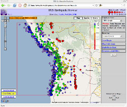
IRIS Earthquake Browser (IEB)
The IEB combines the DMC's large database of earthquakes
with the popular Google Maps web interface. The IEB is useful
both educationally and as a research tool. With the IEB you can
quickly find earthquakes in any region of the globe and then
import this information into the GEON Integrated Data Viewer
(IDV) where the hypocenters may be visualized in three dimensions.
IEB | Learn
more
|