Coordinate Acquisition Tool (CAT) Integrated into SeismiQuery
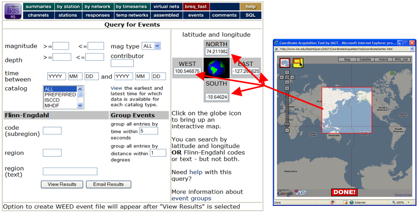
The Institute for the Application of Geospatial Technology at Cayuga Community College (IAGT – http://www.iagt.org) is pleased to announce the release of its Coordinate Acquisition Tool (CAT) for Google Maps. CAT has been integrated into the DMC SeismiQuery software application (http://ds.iris.edu/SeismiQuery/sq-eventsmag.htm) that provides access to all IRIS seismic data. CAT provides an easy way to fetch geographic coordinates from a simple map interface. The tool is launched in a popup window from a parent html application, in this case by clicking on the globe image in the ‘latitude and longitude’ section of SeismiQuery (Fig. 1). The coordinates are obtained by either getting the current map extent, or by dragging a rectangle within the extent. They are then returned to the parent page, in this case to populate text boxes corresponding to the respective bounding geographic extents to be used as a filter for further SeismiQuery interaction.

Some technical aspects of the CAT:
- Written in HTML/JavaScript, and designed to be launched in a popup window.
- Uses the drag_zoom.js JavaScript library, which has been adopted by Google from the original “GZoom” library. Also uses Walter Zorn’s vector JavaScript library. These libraries are responsible for the rectangle effects.
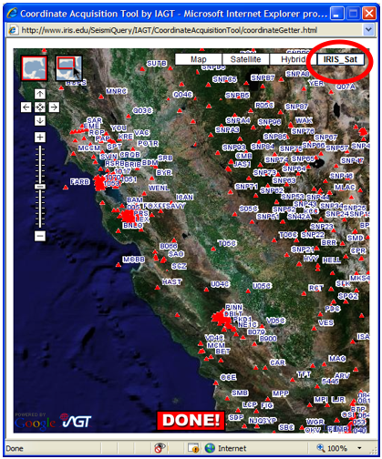
- Uses a freely available WMS JavaScript library, created primarily for use with Google Maps. This library allows one to overlay your own WMS data over Google Maps data (Fig. 2), or to simply create your own WMS map (combining map layers from multiple servers).
- A CustomButtonControl class has been included which is used for the Map Extent button, and which could be leveraged to make other tool buttons (with on/off states).

For more information regarding the CAT, contact Dan Deneau at IAGT (ddeneau@iagt.org).
IAGT has been providing geospatial tools and technical support to IRIS through funding from NASA under the EarthScope program, and has been a partner since the very beginning of the NSF funded program. For instance, IAGT has been providing routine updates of Google Earth kmz files that show the current state of the Transportable Array and provide links to station information (http://arcserver1.iagt.org/TacoKMZ/TacoKMZ.aspx linked from http://www.usarray.org/researchers/obs/transportable). Another example is the ‘Suggest a Site’ application (http://www.usarray.org/public/suggest) that IRIS is using to engage the public in the Transportable Array siting process.
IAGT also provides geospatial support to UNAVCO under the Plate Boundary Observatory (PBO) component of EarthScope, and has developed extensive geospatial analysis and visualization tools under that component for instrument site selection and information management. Examples include: a web-based application for determining line-of-sight between distributed communications infrastructure in remote areas (http://www.iagt.org/earthscope/es-viewshed.asp); the PBO Network Progress and State of Health interactive mapping components (http://pbowms.unavco.org/shared/scripts/mapping/map.shtml?map=progress); and the creation of Network Progress Google Earth kmz station files (http://pboweb.unavco.org/local/downloads/gearth/pbonetwork.kmz).
For general information regarding IAGT’s geospatial technical development services, contact Fred Pieper (fpieper@iagt.org).
Go to: CAT using SeismiQuery
by Dan Deneau , Fred Pieper and Dana Piwinski (IAGT)


