Summary
ANA2_P_2018 is a regional finite-frequency teleseismic P-wave tomography model for the Eastern Mediterranean.
Quicklinks
Description
| Name | ANA2_P_2018 |
| Title | Regional finite-frequency teleseismic P-wave tomography model for the Eastern Mediterranean |
| Type | 3-D Tomography Earth Model |
| Sub Type | Relative P-wave velocity (%dVp) |
| Year | 2018 |
| Short Description | This model uses relative arrival time residuals from 936 earthquakes recorded at 313 stations of a variety of temporary and permanent seismic deployments in Turkey, Greece, Cyprus, and Armenia. Residuals are measured in four frequency bands and inverted in a finite-frequency tomographic inversion. |
| Authors: | |
| Daniel Evan Portner | |
| Department of Geosciences, University of Arizona, Tucson, AZ USA | |
| Jonathan R. Delph | |
| Department of Earth, Environmental, and Planetary Science, Rice University, Houston, TX USA | |
| C. Berk Biryol | |
| Department of Geological Sciences, University of North Carolina, Chapel Hill, NC USA | |
| Susan L. Beck | |
| Department of Geosciences, University of Arizona, Tucson, AZ USA | |
| George Zandt | |
| Department of Geosciences, University of Arizona, Tucson, AZ USA | |
| A. Arda Özacar | |
| Department of Geological Engineering, Middle East Technical University, Ankara, Turkey | |
| Eric Sandvol | |
| Department of Geological Sciences, University of Missouri, Columbia, MO USA | |
| Niyazi Türkelli | |
| Kandilli Observatory and Earthquake Research Institute | |
| Department of Geophysics, Bogazici University, Istanbul, Turkey | |
| Previous Model | None |
| Reference Model | IASP91 |
| Model Download | |
| ANA2-P-2018_percent.nc is the netCDF file for the model (see metadata) | |
| Depth Coverage | From 60 km to 1010 km (best resolution 100-900 km). |
| Area | Anatolia and the Aegean Sea |
| Data Set Description | The model uses relative arrival time residuals from 936 earthquakes recorded at 313 stations of a variety of temporary and permanent seismic deployments in Turkey, Greece, Cyprus, and Armenia. |
| Supplemental Information | |

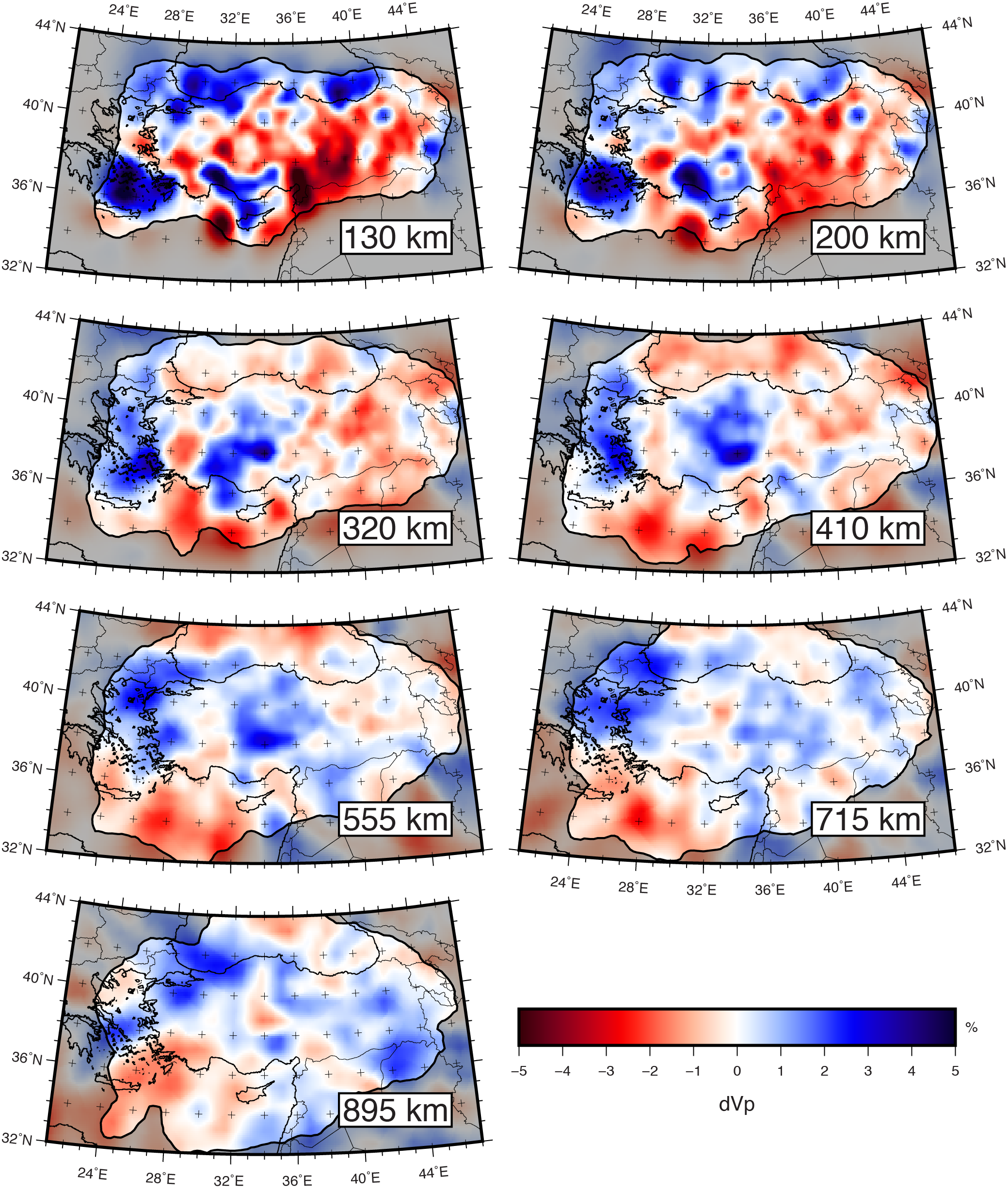
320 km, 410 km, 555 km, 715 km, and 895 km. Color scale
for P-wave velocity perturbations.
Citations and DOIs
To cite the original work behind this Earth model:
- Portner, D.E., Delph, J.R., Biryol, C.B., Beck, S.L., Zandt, G., Özacar, A.A., Sandvol, E., and Türkelli, N., 2018, Subduction termination through progressive slab deformation across Eastern Mediterranean subduction zones from updated P-wave tomography beneath Anatolia: Geosphere, v. 14, no. 3, p. 1–19, https://doi.org/10.1130/GES01617.1.
To cite IRIS DMC Data Products effort:
- Trabant, C., A. R. Hutko, M. Bahavar, R. Karstens, T. Ahern, and R. Aster (2012), Data Products at the IRIS DMC: Stepping Stones for Research and Other Applications, Seismological Research Letters, 83(5), 846–854, https://doi.org/10.1785/0220120032.
DOI for this EMC webpage:
Credits
Model provided by Daniel Evan Portner
Timeline
- 2018-05-15
- online


