Summary
SoCal.ANT_Vph+HV-1.Berg.2018, Berg et al., (2018), is a shear wave velocity model from joint inversion of Rayleigh ellipticity and phase velocity from ambient noise from ambient noise cross-correlations of Southern California using continuous seismic data from stations (available through the Southern California Earthquake Data Center and IRIS Data Center).
Quicklinks
Description
| Name | SoCal.ANT_Vph+HV-1.Berg.2018 | ||
| Title | 3D shear-wave velocity model of Southern California from joint inversion of Rayleigh wave ellipticity and phase velocity from ambient noise cross-correlations. | ||
| Type | 3-D Tomography Earth Model | ||
| Sub Type | Shear-wave velocity (km/s) | ||
| Year | 2018 | ||
| Short Description | SoCal.ANT_Vph+HV-1.Berg.2018 is a shear wave velocity model from joint inversion of Rayleigh ellipticity and phase velocity from ambient noise from ambient noise cross-correlations of Southern California using continuous seismic data from stations (available through the Southern California Earthquake Data Center and IRIS Data Center). |
||
| Authors: | |||
| Elizabeth M. Berg | |||
| Department of Geology & Geophysics | |||
| University of Utah | |||
| 115 South 1460 East, Salt Lake City, UT 84112, USA | |||
| Fan-Chi Lin | |||
| Department of Geology & Geophysics | |||
| University of Utah | |||
| 115 South 1460 East, Salt Lake City, UT 84112, USA | |||
| Amir Allam | |||
| Department of Geology & Geophysics | |||
| University of Utah | |||
| 115 South 1460 East, Salt Lake City, UT 84113, USA | |||
| Hongrui Qiu | |||
| Department of Earth Sciences | |||
| University of Southern California | |||
| 3651 Trousdale Pkwy | |||
| Los Angeles, CA, USA | |||
| Weisen Shen | |||
| Department of Geosciences | |||
| Stony Brook University | |||
| 255 Earth and Space Sciences Building (ESS) | |||
| Stony Brook, NY, USA | |||
| Yehuda Ben-Zion | |||
| Department of Earth Sciences | |||
| University of Southern California | |||
| 3651 Trousdale Pkwy | |||
| Los Angeles, CA, USA | |||
| Previous Model | None | ||
| Reference Model | None |
| Model Download | SoCal.ANT-Vph+HV-1.Berg.2018.nc (see metadata ), is the netCDF file for the model |
| Model Homepage | None |
| Depth Coverage | 0 to 48.5 km (below earth surface) |
| Area | Southern California (latitude 32.2°N/36.2°N, longitude: 121°W/114°W) |
| Data Set Description | [Berg et al., (2018)] Dataset incluse S-wave velocity structure across Southern California from joint inversion of ambient noise tomography (phase velocity) and Rayleigh wave ellipticity |

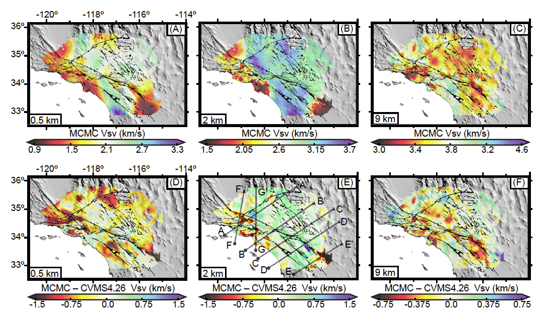
(b) 2 km, and© 9 km. Also shown are the differences between final and starting models for
depths of (d) 0.5 km (e) 2 km (f) 9 km. Cross-sections denoted in (e) are shown in the next figure.

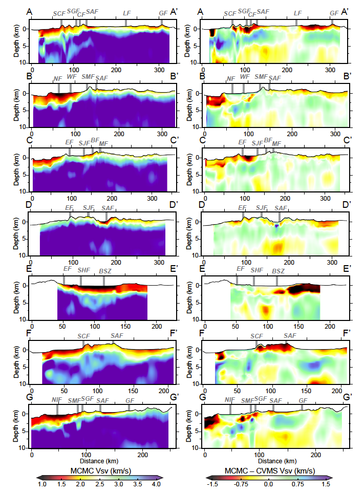
difference between final and initial (CVMS) Vsv. (a) A-A’ cross section with the San
Cayetano, San Gabriel, Clearwater, San Andreas, Lockhart and Garlock Fault surface
traces marked. (b) B-B’ cross-sections with the Newport-Inglewood, Whittier, Sierra
Madre and San Andreas fault surface traces marked. (c) C-C’ cross-sections with
Elsinore, San Jacinto, Banning and Mill Creek fault surface traces marked. (d) D-D’
cross-section with Elsinore, San Jacinto and San Andreas fault surface traces marked. (e)
E-E’ cross-section with Elsinore and Superstition Hills faults and Brawley seismic zone
labeled. (f) F-F’ cross-section with San Cayetano and San Andreas faults marked. (g)
G-G’ cross section with Newport-Inglewood, Sierra Madre, San Gabriel, San Andreas,
and Garlock faults marked.
Citations and DOIs
To cite the original work behind this Earth model:
- Berg, E. M., Lin, F.‐C., Allam, A., Qiu, H., Shen, W., & Ben‐Zion, Y. (2018). Tomography of Southern California via Bayesian joint inversion of Rayleigh wave ellipticity and phase velocity from ambient noise cross‐correlations. Journal of Geophysical Research: Solid Earth, 123, 9933–9949. https://doi.org/10.1029/2018JB016269.
To cite IRIS DMC Data Products effort:
- Trabant, C., A. R. Hutko, M. Bahavar, R. Karstens, T. Ahern, and R. Aster (2012), Data Products at the IRIS DMC: Stepping Stones for Research and Other Applications, Seismological Research Letters, 83(5), 846–854, https://doi.org/10.1785/0220120032.
DOI for this EMC webpage:
References
- Allam, A. A., Ben-Zion, Y., Kurzon, I., & Vernon, F. (2014). Seismic velocity structure in the hot springs and trifurcation areas of the San Jacinto fault zone, California, from double-difference tomography. Geophysical Journal International, 198(2), 978–999. https://doi.org/
https://doi.org/10.1093/gji/ggu176
- Lee, E. J., Chen, P., Jordan, T. H., Maechling, P. B., Denolle, M. A., & Beroza, G. C. (2014). Full-3-D tomography for crustal structure in southern California based on the scattering-integral and the adjoint-waveform methods. Journal of Geophysical Research: Solid Earth, 119, 6421–6451. https://doi.org/
https://doi.org/10.1002/2014JB011346
- Qiu, H., Ben-Zion, Y., & Lin, F.-C. (2018). Eikonal tomography of the Southern California plate boundary region. Abstract of the Annual Meeting of the American Geophysical Union.
- Tape, C., Liu, Q., Maggi, A., & Tromp, J. (2009). Adjoint tomography of the southern California crust. Science, 325(5943), 988–992. https://doi.org/
https://doi.org/10.1126/science.1175298
- Tape, C., Liu, Q., Maggi, A., & Tromp, J. (2010). Seismic tomography of the southern California crust based on spectral-element and adjoint methods. Geophysical Journal International, 180(1), 433–462. https://doi.org/
https://doi.org/10.1111/j.1365-246X.2009.04429.x
- Zigone, D., Ben-Zion, Y., Campillo, M., & Roux, P. (2015). Seismic tomography of the Southern California plate boundary region from noisebased Rayleigh and Love waves. Pure and Applied Geophysics, 172(5), 1007–1032. https://doi.org/
https://doi.org/10.1007/s00024-014-0872-1
Credits
Model provided by Elizabeth M. Berg
Timeline
- 2019-03-04
- online


