Summary
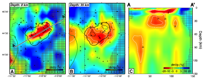
YS-P-H15 is a 3D P-wave velocity model of Yellowstone from joint inversion of local earthquake and teleseismic travel-time data
Quicklinks
Description
| Name | YS-P-H15 |
| Title | 3D P-wave velocity model of Yellowstone from joint inversion of local earthquake and teleseismic travel-time data |
| Type | 3-D Tomography Earth Model |
| Sub Type | P-wave velocity (km/s) and perturbation (%) |
| Year | 2015 |
| Short Description | The model integrates local earthquake and teleseismic travel-time data into one inversion to constrain the 3-D P-wave velocity structures of Yellowstone from the upper mantle to the upper crust. |
| Authors: | |
| Hsin-Hua Huang | |
| Department of Geology and Geophysics / Seismological Laboratory | |
| University of Utah / California Institute of Technology | |
| Salt Lake City, UT 84112, USA / Pasadena, CA 91125, USA | |
| Fan-Chi Lin | |
| Department of Geology and Geophysics | |
| University of Utah | |
| Salt Lake City, UT 84112, USA | |
| Brandon Schmandt | |
| Department of Earth and Planetary Sciences | |
| University of New Mexico | |
| Albuquerque, NM 87131, USA | |
| Jamie Farrell | |
| Department of Geology and Geophysics | |
| University of Utah | |
| Salt Lake City, UT 84112, USA | |
| Robert B. Smith | |
| Department of Geology and Geophysics | |
| University of Utah | |
| Salt Lake City, UT 84112, USA | |
| Victor C. Tsai | |
| Seismological Laboratory | |
| California Institute of Technology | |
| Pasadena, CA 91125, USA | |
| Previous Model | None |
| Reference Model | None |
| Model Download | |
| YS-P-H15.nc (metadata ), is the netCDF file for the model | |
| Model Homepage | http://h3uang.blogspot.com/2015/08/ys-p-h15.html |
| Depth Coverage | -4 to 160 km (0 km refers to sea level) |
| Area | Yellowstone (latitude: 43.55°/45.2°, longitude: -111.55°/-109.75°) |
| Data Set Description | [Huang et al. (2015)] Data set includes 47,815 P-wave first arrivals from 4,520 local earthquakes and 4,605 relative arrival times from 329 teleseismic earthquakes recorded by 81 stations from the Yellowstone, Teton, and Snake River Plain regional seismic networks, the NOISY array, and the EarthScope USArray. |
| Supplemental Information | |

Citations and DOIs
To cite the original work behind this Earth model:
- Huang, H.-H., F.-C. Lin, B. Schmandt, J. Farrell, R. B. Smith, and V. C. Tsai (2015), The Yellowstone magmatic system from the mantle plume to the upper crust, Science, 348(6236), 773–776, https://doi.org/10.1126/science.aaa5648.
To cite IRIS DMC Data Products effort:
- Trabant, C., A. R. Hutko, M. Bahavar, R. Karstens, T. Ahern, and R. Aster (2012), Data Products at the IRIS DMC: Stepping Stones for Research and Other Applications, Seismological Research Letters, 83(5), 846–854, https://doi.org/10.1785/0220120032.
DOI for this EMC webpage:
Credits
Model provided by Hsin-Hua Huang
Timeline
- 2015-08-12
- YS-P-H15 online


