EarthScope uses data collected by many seismic stations and other instruments
to explore the structure and evolution of the North American continent.
Nearest EarthScope GPS Stations

You too can measure the motion!
Touch an EarthScope GPS Station (green boxes on the map) to see real-time data showing ground motion.
Touch an EarthScope GPS Station (green boxes on the map) to see real-time data showing ground motion.
Question 1:
Compare the stations near the coast to stations in eastern Oregon and Washington. What do the differences between the charts in these two areas tell us about plate tectonics?
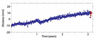
An Example GPS Station Plot
This simplified time series plot is a record of a GPS unit having moved about 20 millimeters (0.79 inches) over a three year period.
This simplified time series plot is a record of a GPS unit having moved about 20 millimeters (0.79 inches) over a three year period.
