![[Geology]](Peter_Mcguire_summary_files/gl.jpg) EAGLE
EAGLE
EAGLE
EAGLEEAGLE 2001 - 2003
The Ethiopian Afar
Geoscientific Lithospheric Experiment
Summary
EAGLE is a major British initiative to investigate how the
African continent is splitting along the Ethiopian Rift in the Horn of
Africa. The project involves the
Universities of Leicester, Leeds and Royal Holloway working with the University
of Addis Abeba and Ethiopian government groups. The work will involve recording seismic
echoes from controlled explosions and natural earthquakes, to provide an image
of the top 100km or so of the Earth; the results will provide the 3-D picture of
a continental rift system immediately prior to the formation of an ocean basin,
a missing snapshot in the study of continental break-up.
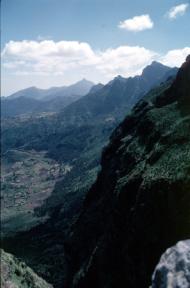
The Ethiopian Rift
 Ethiopia lies where the southern Red Sea and the Gulf of
Aden which are slowly widening to become oceans - meet with one of the major
geological features on the surface of the Earth, the East African Rift
Valley. This extends from the
Zambesi valley in the south through Malawi, Tanzania, Congo, Uganda and Kenya
into the Main Ethiopian Rift Valley before emerging into the furnace-hot region
of Afar at the junction with the Red Sea and Gulf of Aden. The Rift Valley has formed as a result
of the brittle African continental plate responding to stretching forces that
are driven by very slow creep of rocks hundreds of kilometres deep in the
Earth. In time the African plate
will split apart along the line of the Rift Valley and form a new ocean. Here we have one of the very few places
on Earth where we can study the active processes of volcanism and stretching of
the continental plate immediately before flooding by a newly formed ocean.
Ethiopia lies where the southern Red Sea and the Gulf of
Aden which are slowly widening to become oceans - meet with one of the major
geological features on the surface of the Earth, the East African Rift
Valley. This extends from the
Zambesi valley in the south through Malawi, Tanzania, Congo, Uganda and Kenya
into the Main Ethiopian Rift Valley before emerging into the furnace-hot region
of Afar at the junction with the Red Sea and Gulf of Aden. The Rift Valley has formed as a result
of the brittle African continental plate responding to stretching forces that
are driven by very slow creep of rocks hundreds of kilometres deep in the
Earth. In time the African plate
will split apart along the line of the Rift Valley and form a new ocean. Here we have one of the very few places
on Earth where we can study the active processes of volcanism and stretching of
the continental plate immediately before flooding by a newly formed ocean.
Why should we study the
Rift?
 Our aim is to understand one of the fundamental
processes occurring on our Earth, namely the break-up of continents. But there are also immediate economic,
environmental and cultural objectives. We hope to identify possible
geothermal fields in the Rift. Oil
and geothermal exploration geologists also need to know about the embryonic
stages of continental break-up to work out how to discover and exploit reserves
along other continental margins where plates have successfully rifted, e.g. the
oilfields offshore west Africa. The
Rift is environmentally hazardous and our studies will help in both earthquake
and volcanic risk assessment. The
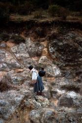
region of Afar is an area closely linked to the development of Man. Anthropologists, archaeologists and
geographers, in their studies of early Man and his interaction with the
environment, need to know about the active processes of rifting; the type of
faulting; the amount and timing of crustal subsidence and uplift; the
distribution of volcanic centres and their associated volcanic rocks.
Our aim is to understand one of the fundamental
processes occurring on our Earth, namely the break-up of continents. But there are also immediate economic,
environmental and cultural objectives. We hope to identify possible
geothermal fields in the Rift. Oil
and geothermal exploration geologists also need to know about the embryonic
stages of continental break-up to work out how to discover and exploit reserves
along other continental margins where plates have successfully rifted, e.g. the
oilfields offshore west Africa. The
Rift is environmentally hazardous and our studies will help in both earthquake
and volcanic risk assessment. The
region of Afar is an area closely linked to the development of Man. Anthropologists, archaeologists and
geographers, in their studies of early Man and his interaction with the
environment, need to know about the active processes of rifting; the type of
faulting; the amount and timing of crustal subsidence and uplift; the
distribution of volcanic centres and their associated volcanic rocks.
EAGLE
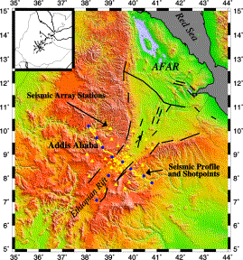
 EAGLE is an international project and will involve more
than 20 scientists in a series of seismic projects in the Ethiopian Rift Valley
and the south-western corner of Afar over a period of more than a year. Two large deployments of seismic
recording instruments will take place between October 2001 and January
2003. In the first deployment
180 instruments including seismometers, data loggers, batteries, solar panels
and GPS receivers will be distributed over a 250x250km2 area covering
the rift and centred on the Nazret volcanic segment to the south-east of Addis
Abeba. This segment lies within a
new zone of active crustal deformation marked by aligned chains of volcanoes,
vents, faults and a 60km long dyke zone comprising vertical intrusions of
magma from deep magma reservoirs.
The instruments will record seismic waves from global and local
earthquakes. These waves will have
travelled up beneath the rift and will provide an image of the Earths crust and
mantle to depths of a few hundred kilometres, illuminating the hot mantle zone
and pockets of molten rock that are believed to underlie this region. The local
earthquakes will provide direct evidence of active faulting and deformation
within the rift.
EAGLE is an international project and will involve more
than 20 scientists in a series of seismic projects in the Ethiopian Rift Valley
and the south-western corner of Afar over a period of more than a year. Two large deployments of seismic
recording instruments will take place between October 2001 and January
2003. In the first deployment
180 instruments including seismometers, data loggers, batteries, solar panels
and GPS receivers will be distributed over a 250x250km2 area covering
the rift and centred on the Nazret volcanic segment to the south-east of Addis
Abeba. This segment lies within a
new zone of active crustal deformation marked by aligned chains of volcanoes,
vents, faults and a 60km long dyke zone comprising vertical intrusions of
magma from deep magma reservoirs.
The instruments will record seismic waves from global and local
earthquakes. These waves will have
travelled up beneath the rift and will provide an image of the Earths crust and
mantle to depths of a few hundred kilometres, illuminating the hot mantle zone
and pockets of molten rock that are believed to underlie this region. The local
earthquakes will provide direct evidence of active faulting and deformation
within the rift.
 In January 2003, some 20 scientists will be involved in
the second major experiment, deploying 400 seismic instruments on a 400km long
profile from the Blue Nile in the Ethiopian Highlands to the north of Addis
Abeba, across the Rift and the Nazret volcanic segment, and up and over the
south-eastern flank of the Rift.
The project will require the use of many all-terrain vehicles, drilling
rigs, equipment trucks, infield communication systems and other supply
systems. Eight borehole shots will
be fired on this profile, the resulting seismic data being interpreted in terms
of a very high resolution image to depths of about 50km. This image will show the amount by which
the crust has been stretched, the distribution of sediments and volcanic rocks within the Rift, and
the location of the source for the Nazret volcanic segment beneath the Rift.
In January 2003, some 20 scientists will be involved in
the second major experiment, deploying 400 seismic instruments on a 400km long
profile from the Blue Nile in the Ethiopian Highlands to the north of Addis
Abeba, across the Rift and the Nazret volcanic segment, and up and over the
south-eastern flank of the Rift.
The project will require the use of many all-terrain vehicles, drilling
rigs, equipment trucks, infield communication systems and other supply
systems. Eight borehole shots will
be fired on this profile, the resulting seismic data being interpreted in terms
of a very high resolution image to depths of about 50km. This image will show the amount by which
the crust has been stretched, the distribution of sediments and volcanic rocks within the Rift, and
the location of the source for the Nazret volcanic segment beneath the Rift.
In Closing
The project is one of the largest seismic projects ever undertaken by a group of UK universities. It will link with projects undertaken by US and European scientists. It will involve young scientists at the outset of their careers and will forge strong links with Ethiopian colleagues. The results will be of importance to all Earth Scientists and will be published in the international scientific journals and popular literature. It is an Earth Science project for the beginning of the 3rd millennium!
Professor Peter
Maguire (University of Leicester)
Dr. Cindy
Ebinger, Dr. Mary Fowler, (Royal Holloway, University of London)
Dr. Graham
Stuart, Dr. Mike Kendall (University of Leeds)
![[Leicester University]](Peter_Mcguire_summary_files/lhomebut.gif)
![[Back]](Peter_Mcguire_summary_files/backbut.gif) Back to Peter
Maguire
Back to Peter
Maguire
The views expressed in this document are those of the
document owner.
If you are an authorised user you may
edit
this document through your Web browser.