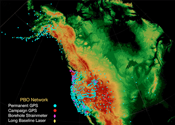
Plate Boundary Observatory
The Plate Boundary Observatory (PBO), part of the National Science Foundation-funded EarthScope project, is designed to study the three-dimensional strain field resulting from deformation across the active boundary zone between the Pacific and North American plates in the western United States. PBO will enable scientists to study these effects by installing and operating a network of 840 continuously operating GPS stations, up to 174 borehole strainmeter stations, and five laser strainmeters. Data from the first PBO strainmeters are now flowing into archives at the IRIS Data Management Center and Northern California Earthquake Data Center.
The two main sensors for each PBO borehole strainmeter (BSM) station are a Gladwin tensor strainmeter recording four components of strain and a three-component Malin L-22 seismometer, both installed near the bottom of a borehole 200-250 meters deep. Other sensors include a downhole pore-pressure and temperature sensor, a surface barometer, surface thermometer, and a rainfall gauge. Each PBO laser strainmeter (LSM) station measures one component of linear strain along baseline between 100 and 1000 meters long, along with a variety of environmental correction series including end-monument motion, outside air and ground temperatures, and instrument state of health.

Data from June 2005 to the present are available from three PBO BSM stations, installed on the Olympic Peninsula (P403, B004, and B001); from the first PBO LSM station, installed along the southern San Andreas fault (DHL2); and from the previously operating Glendale-Verdugo LSM (GVS1), located near the Sierra Madre Fault. Raw data are available in both the native logger format (bottle for the BSM stations and Ice-Nine for the LSM stations) and in standard SEED format.
The SEED data are available from the DMC and NCEDC using all standard SEED request mechanisms (see http://ds.iris.edu/data/ and http://www.ncedc.org/ncedc/access.html for tutorials). The SEED network code for all data from PBO strainmeter stations is PB. The BSM site codes are B001 (Golbeck1), B004 (Hoko Falls), and P403 (Floe Quarry); the LSM site codes are DHL2 (Durmid Hill 2) and GVS1 (Glendale-Verdugo 1). The channel and location codes are given in Tables 1 and 2 below.
Table 1: PBO Site Codes
| Site Code | 16-character station name | Location |
|---|---|---|
| Borehole Strainmeter Stations | ||
| B001 | Golbeck01BWA2005 | Sequim, Washington |
| B004 | HokoFallsBWA2005 | Hoko Falls, Washington |
| P403 | FloeQuaryBWA2005 | Snider, Washington |
| Laser Strainmeter Stations | ||
| DHL2 | DurmidHillCS2005 | Durmid Hill, California |
| GVS1 | GlendallSMCS2005 | Glendale, California |
Table 2: PBO Borehole Strainmeter SEED Channel and Location Codes
| SEED Codes | Sample Rate | Description | |
| Channel | Location | (samples/sec) | |
| BS1 | T0 | 20 | GTSM Strain Channel 1, sampled at 20 samples/sec |
| LS1 | T0 | 1 | GTSM Strain Channel 1, sampled at 1 samples/sec |
| RS1 | T0 | 0.001667 | GTSM Strain Channel 1, sampled once every 600 sec |
| BS2 | T0 | 20 | GTSM Strain Channel 2, sampled at 20 samples/sec |
| LS2 | T0 | 1 | GTSM Strain Channel 2, sampled at 1 samples/sec |
| RS2 | T0 | 0.001667 | GTSM Strain Channel 2, sampled once every 600 sec |
| BS3 | T0 | 20 | GTSM Strain Channel 3, sampled at 20 samples/sec |
| LS3 | T0 | 1 | GTSM Strain Channel 3, sampled at 1 samples/sec |
| RS3 | T0 | 0.001667 | GTSM Strain Channel 3, sampled once every 600 sec |
| BS4 | T0 | 20 | GTSM Strain Channel 4, sampled at 20 samples/sec |
| LS4 | T0 | 1 | GTSM Strain Channel 4, sampled at 1 samples/sec |
| RS4 | T0 | 0.001667 | GTSM Strain Channel 4, sampled once every 600 sec |
| VDD | TP | 0.1 | Downhole pore pressure |
| VKD | TP | 0.1 | Downhole temperature recorded at the pore pressure sensor, ap- proximately 100 meters deep in the borehole |
| LDO | TS | 1 | Atmospheric pressure |
| RDO | TS | 0.0005556 | Atmospheric pressure |
| RRO | TS | 0.0005556 | Rainfall |
| RK1 | T0 | 0.0005556 | Logger temperature |
| RKD | T0 | 0.0005556 | Downhole temperature, measured by a thermistor inside the GTSM sonde |
| REO | T0 | 0.0005556 | Solar amps |
| RE1 | T0 | 0.0005556 | Battery voltage |
| RK2 | T0 | 0.0005556 | Power box temp |
| RE2 | T0 | 0.0005556 | System amps |
Note: There are also 24 calibration channels available under channel codes RCA, RCB, RCC, and RCD with location codes T1 through T6.
For more information, please visit the PBO web site or contact Greg Anderson, PBO Data Products Manager, at (303) 381-7555 or anderson@unavco.org.
The Plate Boundary Observatory is the geodetic component of EarthScope, operated by UNAVCO and funded by the National Science Foundation. EarthScope is funded by the National Science Foundation and conducted in partnership with the US Geological Survey and NASA.
by Greg Anderson (UNAVCO)


