


Summary
CRUST1.0 (Laske, Ma, Masters & Pasyanos, 2013) is a global crustal model specified on a 1-by-1 degree grid and incorporates an updated version of the global sediment thickness. This higher-resolution crustal model supersedes the older CRUST2.0 model.
Quicklinks
Description
| Name | CRUST1.0 |
| Title | A 1-by-1 Degree Global Model of Earth’s Crust |
| Type | Crustal Earth Model |
| Sub Type | Crustal profile |
| Year | 2013 |
| Data Revision | r0.1 (revision history) |
| Short Description |
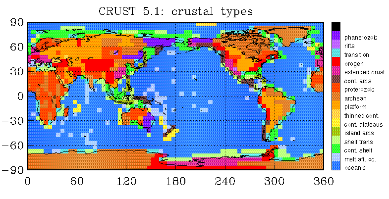
The CRUST1.0 (Laske, Ma, Masters & Pasyanos, 2013), is a global crustal model specified on a 1-by-1 degree grid and incorporates an updated version of the global sediment thickness. This higher-resolution crustal model supersedes the older CRUST2.0 model. Bathymetry and topography is that of ETOPO1. ETOPO1 is a 1-arc minute model of Earth’s global relief, including surface topography and seafloor bathymetry. In ice-covered regions, ice surface and bedrock are given. From the ETOPO1 files, topography, bathymetry and ice thickness are derived in this model by binning and averaging the ETOPO1 data in 1-degree cells. The global crustal models CRUST5.1 and CRUST2.0 use type keys to assign various types of crustal structure (such as Archean, early Proterozoic, rifts etc.) in each cell. In both of these models, the crustal types were also used to assign ice, sediment and crustal thickness. In CRUST1.0, the principal crustal types are adopted from CRUST5.1 and CRUST2.0. But local ice, sediment and crustal thicknesses are now directly implemented in CRUST1.0 and the crustal types are now aligned with the crustal age map of Artemieva and Mooney (2001). Additional crustal types mark specific tectonic settings, such as orogens, continental rifts, continental shelves and oceanic plateaus. CRUST1.0 also has a few new types, including one for very young (< 3 Myrs) oceans. In contrast to older models, the function of crustal types in CRUST1.0 is limited to assigning elastic parameters to layers in the crystalline crust. CRUST1.0 consists of less than 40 crustal types. Each of the 1×1-degree cells has a unique 8-layer crustal profile where the layers are: 1. water 2. ice 3. upper sediments (Vp, Vs, rho not defined in all cells) 4. middle sediments (Vp, Vs, rho not defined in all cells) 5. lower sediments (Vp, Vs, rho not defined in all cells) 6. upper crust 7. middle crust 8. lower crust Parameters Vp, Vs and rho are given explicitly for these 8 layers as well as Vpn, Vsn and rho values for a ninth layer below the Moho. The parameters below the Moho are determined using a modified version of the recent Pn model LLNL-G3Dv3. |
| Usage Notes | Each layer in this model is represented as a single 2D variable (for example, see CRUST1.0-vp.r0.1.nc metadata). |
| Authors: | |
| Gabi Laske | |
| IGPP, Scripps Institution of Oceanography | |
| U.C. San Diego | |
| La Jolla, CA, USA | |
| Guy Masters | |
| IGPP, Scripps Institution of Oceanography | |
| U.C. San Diego | |
| La Jolla, CA, USA | |
| Zhitu Ma | |
| Department of Earth and Planetary Sciences (formerly at IGPP) | |
| Harvard University | |
| Cambridge, Massachusetts, USA | |
| Mike Pasyanos | |
| Atmospheric, Earth, and Energy Division | |
| Lawrence Livermore National Laboratory | |
| Livermore, CA, USA | |
| Base Model | CRUST2.0 |
| Referenced by | Africa.ANT.Emry-etal.2018 |
| Model Download | |
| CRUST1.0-vp.r0.1.nc is the netCDF file for the above model containing compressional velocity (Vp, km.s-1) for the model layers. See CRUST1.0-vp.r0.1 metadata for a complete list of the model variables. CRUST1.0-vs.r0.1.nc is the netCDF file for the above model containing shear velocity (Vs, km.s-1) for the model layers. See CRUST1.0-vs.r0.1 metadata for a complete list of the model variables. CRUST1.0-rho.r0.1.nc is the netCDF file for the above model containing density (rho, g.cm-3) for the model layers. See CRUST1.0-rho.r0.1 metadata for a complete list of the variables. |
|
| Model Homepage | https://igppweb.ucsd.edu/~gabi/crust1.html |
| Depth Coverage | 0 km to the Moho depth |
| Area | Global |

under the western hemisphere from CRUST1.0-vp.r0.1.nc, using emc-ParaView plugins.

western hemisphere from CRUST1.0-vp.r0.1.nc, using emc-ParaView plugins.
Citations and DOIs
To cite the original work behind this Earth model:
- Laske, G., Masters., G., Ma, Z. and Pasyanos, M., Update on CRUST1.0 – A 1-degree Global Model of Earth’s Crust, Geophys. Res. Abstracts, 15, Abstract EGU2013-2658, 2013.
To cite IRIS DMC Data Products effort:
- Trabant, C., A. R. Hutko, M. Bahavar, R. Karstens, T. Ahern, and R. Aster (2012), Data Products at the IRIS DMC: Stepping Stones for Research and Other Applications, Seismological Research Letters, 83(5), 846–854, https://doi.org/10.1785/0220120032.
DOI for this EMC webpage:
Reference
- Artemieva, I.M. and Mooney, W.D., Thermal thickness and evolution of Precambrian lithosphere: A global study, J. Geophys. Res., 106, 16,387 – 166, 414, 2001.
- CRUST 2.0 was introduced in a 2000 AGU poster. The abstract is: Bassin, C., Laske, G. and Masters, G., The Current Limits of Resolution for Surface Wave Tomography in North America, EOS Trans AGU, 81, F897, 2000.
- A description of CRUST 5.1 can be found in: Mooney, Laske and Masters, CRUST 5.1: a global crustal model at 5×5 degrees, JGR, 103, 727-747, 1998.
Credits
- Model provided by Gabi Laske
Revision History
revision r0.0: uploaded on 2020-01-29.
revision r0.1: uploaded on 2022-01-28. This version contains some updates to the metadata. Comments have been added to the global variables indicating that latitude and longitude are for the center of cells. Also, comments have been added to the variables indicating that the values are for the cell centers.
Timeline
- 2020-01-29
- online
- 2022-01-28
- r0.1 online


