Summary
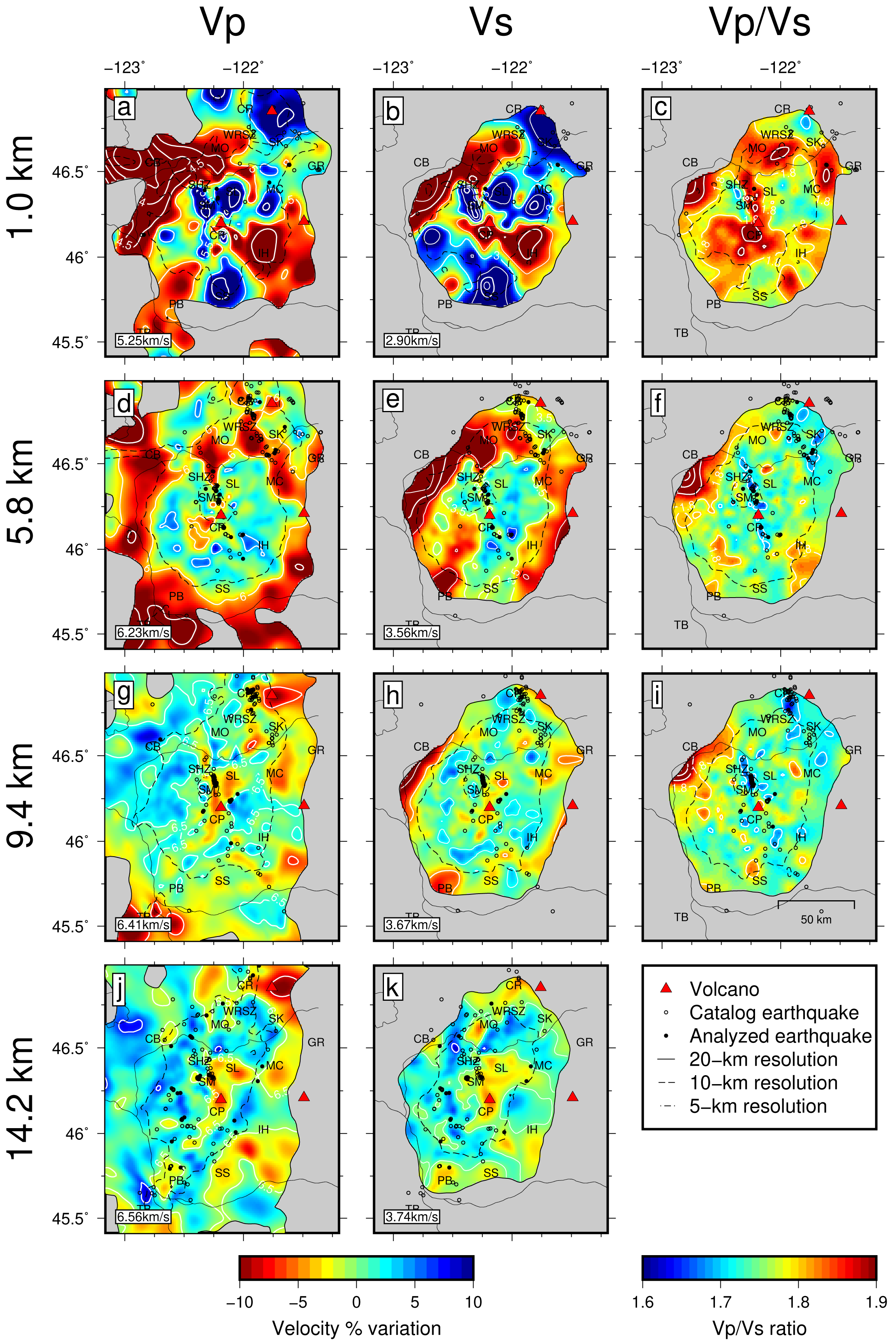
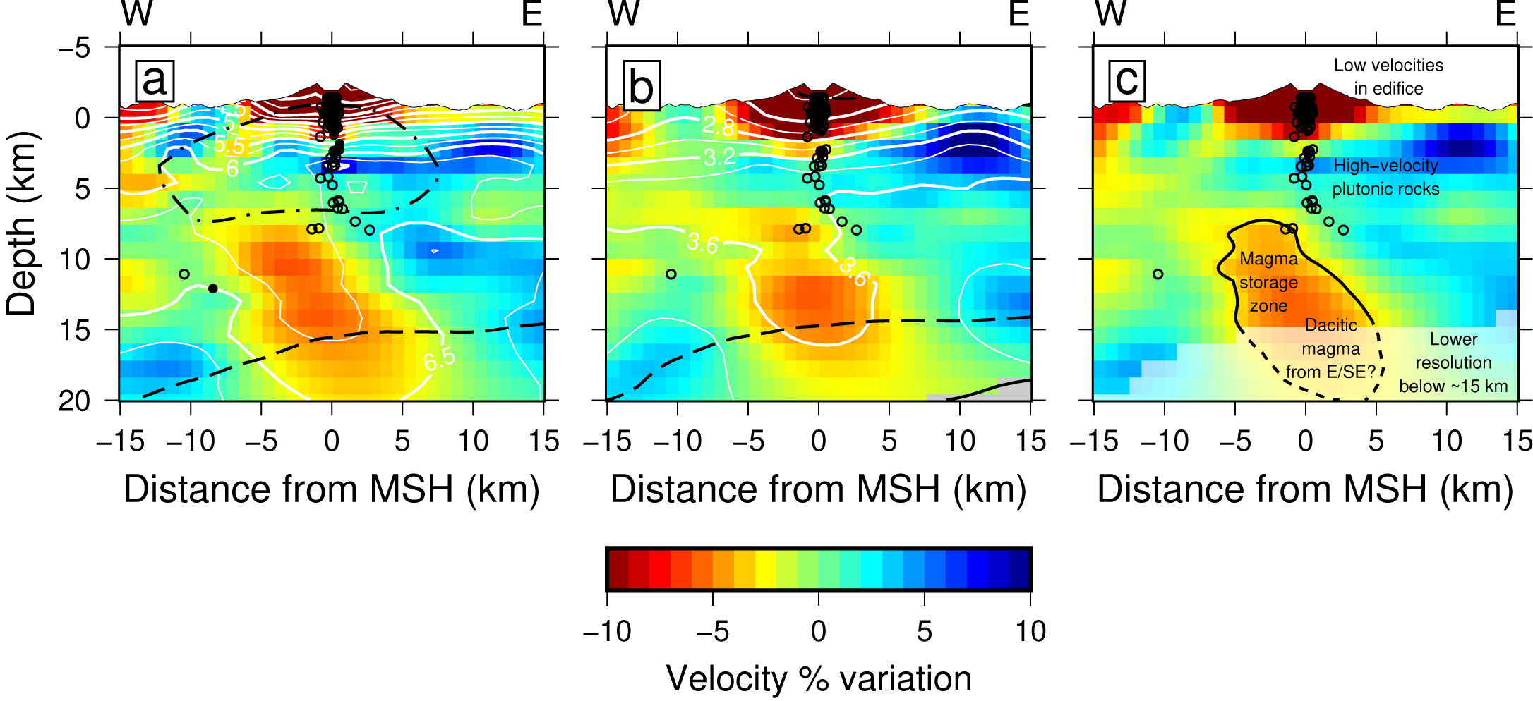
iMUSH_localEQ_Ulberg_2020 contains 3-D Vp and Vs velocity models of the upper crust near Mount St. Helens, WA, obtained using local-source travel-time tomography.
Quicklinks
Description
| Name | iMUSH_localEQ_Ulberg_2020 | ||
| Title | 3-D velocity models of the Mount St. Helens region using local-source travel-time tomography | ||
| Type | 3-D Tomography Earth Model | ||
| Sub Type | Compressional and shear-wave velocity (km/s) | ||
| Year | 2020 | ||
| Short Description | iMUSH_localEQ_Ulberg_2020 contains 3-D Vp and Vs velocity models of the upper crust near Mount St. Helens, WA, obtained using local-source travel-time tomography. Velocities were obtained using an iterative, nonlinear, conjugate gradient, least squares inversion code with a finite-difference 3-D eikonal equation solver. |
||
| Authors: | |||
| Carl Ulberg Earth and Space Sciences, University of Washington, Seattle, WA, USA | |||
| Kenneth Creager Earth and Space Sciences, University of Washington, Seattle, WA, USA | |||
| Seth Moran United States Geological Survey Cascades Volcano Observatory, Vancouver, WA, USA | |||
| Geoffrey Abers Earth and Atmospheric Sciences, Cornell University, Ithaca, NY, USA | |||
| Weston Thelen United States Geological Survey Cascades Volcano Observatory, Vancouver, WA, USA | |||
| Alan Levander Earth, Environmental, and Planetary Science, Rice University, Houston, TX, USA | |||
| Eric Kiser Geosciences, University of Arizona, Tucson, AZ, USA | |||
| Brandon Schmandt Earth and Planetary Science, University of New Mexico, Albuquerque, NM, USA | |||
| Steven Hansen Earth and Planetary Sciences, Macquarie University, Sydney, New South Wales, Australia | |||
| Robert Crosson Earth and Space Sciences, University of Washington, Seattle, WA, USA | |||
| Previous Model | N/A | ||
| Reference Model | N/A | ||
| Model Homepage | |||
| Model Download | iMUSH-localEQ-Ulberg-2020.nc (see metadata), is the netCDF file for the model | ||
| Model Homepage | None | ||
| Depth Coverage | -5 to 55 km (bsl) | ||
| Area | Mount St. Helens region (latitude 45.18°/47.34°, longitude -123.71°/-120.69°) | ||
| Data Set Description | [Ulberg et al., 2020] Five absolute velocity models were produced using arrival times from local earthquakes and active blasts: the ‘normal’ Vp (~29,000 arrival times), ‘normal’ Vs (~4700), ‘matched’ Vp and Vs (~3600; these were calculated in order to obtain a more robust Vp/Vs measurement), and ‘large’ Vp (~74,000) models. Velocity perturbation plots in Ulberg et al. (2020) were made using depth-averaged velocities from these models (Table S2). | ||
| Model Resolution | The models have 1.2-km node spacing in all directions. Unmasked regions correspond to strong semblance (recovery of checkerboard patterns) for features of 20-km width. Depth resolution is generally best from the surface to 20 km depth. |


Citations and DOIs
To cite the original work behind this Earth model:
- Ulberg, C. W., Creager, K. C., Moran, S. C., Abers, G. A., Thelen, W. A., Levander, A., et al. ( 2020). Local source Vp and Vs tomography in the Mount St. Helens region with the iMUSH broadband array. Geochemistry, Geophysics, Geosystems, 21, e2019GC008888. https://doi.org/10.1029/2019GC008888
To cite IRIS DMC Data Products effort:
- Trabant, C., A. R. Hutko, M. Bahavar, R. Karstens, T. Ahern, and R. Aster (2012), Data Products at the IRIS DMC: Stepping Stones for Research and Other Applications, Seismological Research Letters, 83(5), 846–854, https://doi.org/10.1785/0220120032.
DOI for this EMC webpage:
Credits
Model provided by Carl Ulberg
Timeline
- 2020-05-06
- online


