Summary
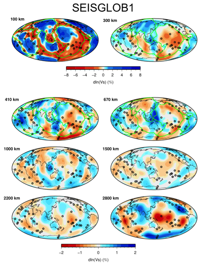
Model based on the joint inversion of splitting and cross-coupling coefficients of normal modes and Rayleigh phase velocity perturbations. We also invert for the crust.
Quicklinks
Description
| Name | SEISGLOB1 |
| Title | Model based on the joint inversion of normal modes and surface waves. |
| Type | 3-D Tomography Earth Model |
| Sub Type | Shear-wave velocity (%) |
| Year | 2016 |
| Short Description | SEISGLOB1 is a pure Sv tomographic model based on the joint inversion of Rayleigh surface wave phase velocity perturbations and splitting and coupling coefficients of normal modes. It is parameterized laterally in spherical harmonics up to degree 20 and with 21 splines in depth (the same as in S40RTS (Ritsema et al. (2011))). The model values are in percent with respect to the reference model PREM (Dziewonski & Anderson (1981)). |
| Authors: | |
| Stephanie Durand | |
| Institut fuer Geophysik | |
| Muenster, Germany | |
| Eric Debayle | |
| LGL-TPE, CNRS | |
| Villeurbanne, France | |
| Yanick Ricard | |
| LGL-TPE, CNRS | |
| Villeurbanne, France | |
| Sophie Lambotte | |
| EOST | |
| Strasbourg, France | |
| Previous Model | N/A |
| Reference Model | PREM |
| Model Download | SEISGLOB1_percent.nc (see metadata ), is the netCDF file for the model |
| Model Homepage | http://perso.ens-lyon.fr/stephanie.durand/Stephanie_Durand/Welcome.html |
| Depth Coverage | 0 to 2850 km |
| Area | Global coverage (latitude: -89°/89°, longitude: 0°/359°) |
| Data Set Description | The data set includes ~22M Rayleigh surface wave measurements for fundamental-mode and higher-mode up to 5th order phase velocities (Durand et al. (2015)), ~10K normal mode splitting coefficients and ~650 normal mode cross-coupling coefficients. See Durand et al. (2016) for more details. |

Green lines display the plate boundaries and the black circles the hotspots location.
Citations and DOIs
To cite the original work behind this Earth model:
- Durand S., E. Debayle, Y. Ricard, S. Lambotte (2016), Seismic evidence for a change in the large scale tomographic pattern across the D layer, Geophys. Res. Lett., 43(15), 7928-7936. https://doi.org/10.1002/2016GL069650.
To cite IRIS DMC Data Products effort:
- Trabant, C., A. R. Hutko, M. Bahavar, R. Karstens, T. Ahern, and R. Aster (2012), Data Products at the IRIS DMC: Stepping Stones for Research and Other Applications, Seismological Research Letters, 83(5), 846–854, https://doi.org/10.1785/0220120032.
DOI for this EMC webpage:
References
- Durand S., E. Debayle, Y. Ricard, S. Lambotte (2016), Seismic evidence for a change in the large scale tomographic pattern across the D layer, Geophys. Res. Lett., 43(15), 7928-7936
- Durand S., E. Debayle and Y. Ricard, (2015), Rayleigh wave phase velocity and error maps up to the fifth overtone, Geophys. Res. Lett., 42(9), 3266-3272
- Ritsema, J., Deuss, A., van Heijst, H.J., Woodhouse, J.H., 2011, S40RTS: a degree-40 shear-velocity model for the mantle from new Rayleigh wave dispersion, teleseismic traveltime and normal-mode splitting function measurements, Geophys. J. Int., 184, 1,223-1,236.
- Dziewonski, A. M., Anderson, D. l., 1981, Preliminary reference Earth model, Phys. Earth Planet. Sci., 25, 297-236.
Credits
Model provided by Stephanie Durand
Timeline
- 2017-12-14
- online


