Summary
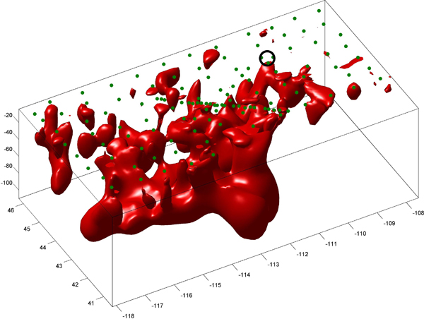
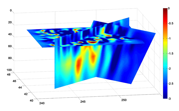
A 3-D regional electrical conductivity model of the crust and upper mantle beneath the Yellowstone/Snake River Plain volcanic province (Idaho and Wyoming, United States) based on magnetotelluric data, Kelbert, Egbert, and deGroot-Hedlin (2012) .
Quicklinks
Description
| Name | SRPY-MT |
| Title | Regional 3-D electrical conductivity model of Snake River Plain / Yellowstone, USA based on magnetotelluric data |
| Type | 3-D Regional Electrical Conductivity Model |
| Sub Type | Long-period Magnetotelluric |
| Units | Siemens/meter |
| Year | 2012 |
| Short Description | Kelbert, Egbert, and deGroot-Hedlin (2012) : This study uses high-quality electromagnetic data obtained through the EarthScope USArray project to obtain detailed three-dimensional images of electrical resistivity / conductivity in the crust and upper mantle beneath the Yellowstone/Snake River Plain volcanic province (Idaho and Wyoming, United States). |
| The lowest resistivities in the area can only plausibly be explained by partial melt and/or fluids, providing valuable new information about the distribution of these phases deep within the Earth beneath the volcanic system. Unexpectedly, in light of the mantle plume models often used to explain Yellowstone volcanism, the electromagnetic data imply that there is no interconnected melt in the lower crust and uppermost mantle directly beneath the modern Yellowstone caldera. Instead, low resistivities consistent with 1-3% melt in the uppermost mantle (depths of 40-80 km) extend at least 200 km southwest of Yellowstone. Shallower areas of reduced resistivity extend upward into the mid-crust around the edges of the seemingly impermeable Snake River Plain province, including beneath Yellowstone. | |
| We suggest that the elevated temperatures beneath the active volcanic center have resulted in greater permeability, allowing magma to ascend to shallower depths and pool in the crust. Little melt is entering the system from below at present, perhaps due to intermittency of supply. | |
| Authors: | |
| A. Kelbert | |
| College of Earth, Ocean and Atmospheric Sciences | |
| Oregon State University | |
| Corvallis, Oregon 97331, USA | |
| G. D. Egbert | |
| College of Earth, Ocean and Atmospheric Sciences | |
| Oregon State University | |
| Corvallis, Oregon 97331, USA | |
| C. deGroot-Hedlin | |
| Scripps Institution of Oceanography | |
| University of California | |
| San Diego, La Jolla, California 92037, USA | |
| Previous Model | N/A |
| Reference Model | N/A |
| Prior Model | 200 Ohm*m halfspace |
| Inversion Software | Modular System for Electromagnetic Inversion, Egbert and Kelbert (2012) |
| Model Download | SRPY-MT.nc (see metadata ), is the netCDF file for the model |
| Model Homepage | N/A |
| Depth Coverage | 10 – 250 km, most reliable to ~100 km depth |
| Area | Snake River Plain / Yellowstone (latitude: 41.0° to 46.5°, longitude: -119.0° to -107.0°) |
| Data Set Description | Frequency domain long-period (10 to 1e4 secs) magnetotelluric (MT) data from 91 EarthScope MT sites, covering much of Idaho and Wyoming, southern Montana, eastern Oregon and northern Nevada, together with 32 sites from an earlier MT survey collected by C. deGroot-Hedlin in two denser profiles along and across the eastern SRP. |


Citations and DOIs
To cite the original work behind this Earth model:
- Kelbert A., Egbert G.D., deGroot-Hedlin C. 2012. “Crust and upper mantle electrical conductivity beneath the Yellowstone Hotspot Track” Geology, v. 40, p. 447-450, https://doi.org/10.1130/G32655.1.
To cite IRIS DMC Data Products effort:
- Trabant, C., A. R. Hutko, M. Bahavar, R. Karstens, T. Ahern, and R. Aster (2012), Data Products at the IRIS DMC: Stepping Stones for Research and Other Applications, Seismological Research Letters, 83(5), 846–854, https://doi.org/10.1785/0220120032.
DOI for this EMC webpage:
References
- Egbert G.D. and A. Kelbert. 2012. “Computational recipes for electromagnetic inverse problems.” Geophysical Journal International, 189:251-267, DOI: https://doi.org/10.1111/j.1365-246X.2011.05347.x.
Credits
Model provided by Anna Kelbert
Timeline
- 2012-08-07
- Online


