The Upgraded IRIS DMC BackProjection data product
The BackProjection data product (BP) codebase has been migrated to Python 3 to increase its flexibility and to enhance its animation and plotting capabilities. The new production code is configurable and can produce back-projection videos and summary plots for custom groups of stations. The Python 3 BP code is publicly available from the IRIS DMC’s GitHub repository
First released in 2011, the BackProjection data product provides beamformed time history and location of coherent short period P-wave energy generated by global M6.5+ earthquakes for four, predefined, virtual networks (NA, EU, AU, GSN). These virtual networks are formed by choosing stations that are within 25 degrees azimuth from the center of North America, Europe, Australia, and the GSN seismic network respectively. Only the stations that are within 30° to 97° from the event, are selected for processing.
The new BP production code (deployed on November 1, 2021), further streamlines the BP production by introducing the following enhancements:
- access to all available open data from seismic stations across multiple FDSN data centers
- use of a binding configuration file that allows users to fine-tune back-projection station selection, processing, and beamforming parameters
- improved plotting capabilities
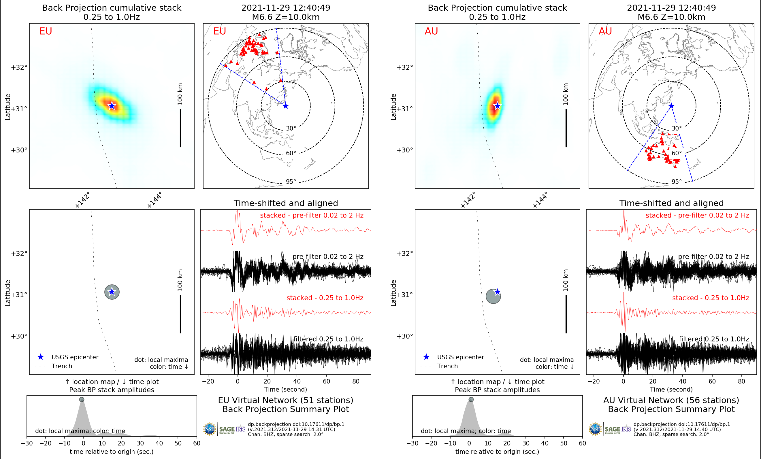
Figure 1 shows the Europe (EU, left) and Australia (AU, right) virtual network’s back-projection summary plots for the M 6.7 event of 2021-11-29 12:40:49, Southeast of Honshu, Japan. A complete set of BP plots and animations for this event is available at http://ds.iris.edu/spud/backprojection/19636287.
The plots in Figure 1are obtained by simply passing the event information (magnitude, depth, latitude, longitude, time) along with the name of the desired virtual network to the BP code, back_projection_r2.py:
back_projection_r2.py -m 6.6 -z 10.0 -y 31.1 -x 142.8 -t 2021-11-29T12:40:49 -n EU
back_projection_r2.py -m 6.6 -z 10.0 -y 31.1 -x 142.8 -t 2021-11-29T12:40:49 -n AU

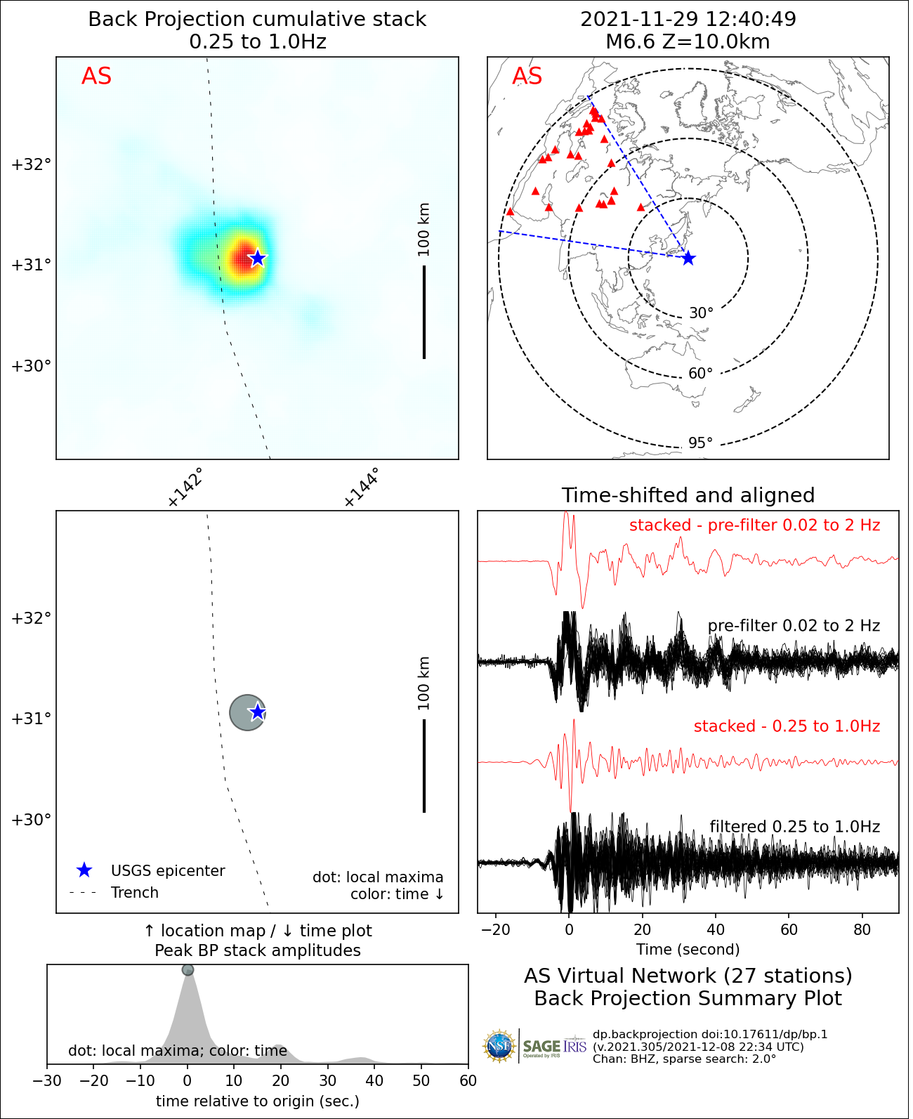
To generate BP summary plots for a different set of stations that are located between EU and AU stations, simply define a new virtual network, such as AS, in the parameter file and set its center at, for example, 44.0° latitude, and 99.0° longitude and then produce a summary plot:
back_projection_r2.py -m 6.6 -z 10.0 -y 31.1 -x 142.8 -t 2021-11-29T12:40:49 -n AS

Further enhancement and tuning of these plots are possible by modifying the processing parameters in the parameter file.
BackProjection Product overview:
https://ds.iris.edu/ds/products/backprojection/
BackProjection GitHub repository:
https://github.com/iris-edu/backprojection
BackProjection data product DOI:
https://doi.org/10.17611/dp/bp.1
BackProjection GitHub repository DOI:
https://doi.org/10.17611/dp/bp.code.1
by Data Products (IRIS DMC)


