IRIS Earthquake Browser
The IRIS DMC is pleased to announce the release of a new generation of web based earthquake query tool – the IRIS Earthquake Browser (IEB). The IEB combines the DMC’s large database of earthquakes with the popular Google Maps web interface. The IEB is useful both educationally and as a research tool. With the IEB you can quickly find earthquakes in any region of the globe and then import this information into the GEON Integrated Data Viewer (IDV) where the hypocenters may be visualized in three dimensions.
The GEON IDV is a powerful, free, Java based, desktop application that allows 3D visualization of complex solid earth science data.
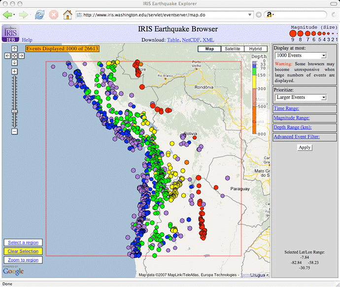
The IEB features a simple, yet powerful, user interface. To start using it, you simply zoom and pan a map of the world just as you would with any other Google map. By default, the IEB shows the most recent 200 events in any given view. The number of events shown can be varied from 100 to 5000 while the prioritization of events (which events have priority to be shown) can be toggled between recent events and larger events.

The 1000 largest events from this region are displayed. A distinctive line of deep (red) events are shown on the eastern side of the selection.
Links at the top of the page allow the user to download the data plotted on the map. The data can be viewed as an HTML table or exported as a NetCDF (Network Common Data Form) binary. The exported NetCDF data can then be imported into the GEON IDV.
Online help gives detailed instructions on how to import data from the IEB into the GEON IDV along with other useful information.
The next image is an animation taken from the GEON IDV using the NetCDF data exported from the previous map. The line of deep events is clearly seen as a straight line at depth.

Advanced Controls
Advanced controls in the IEB allow users to select events by:
- Time Range
- Magnitude Range
- Depth Range
- Catalog
- Contributor
- Magnitude Type
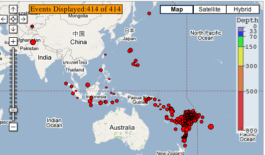
Using these controls can be very informative. For example, constraining event depth ranges from 700 to 900 km shows that the majority of deep events are located near the Tonga trench as shown in the following map (Fig. 3).

Note the proliferation of events located near the Tonga trench, a plate-boundary.
Constraining time ranges can be useful in estimating how many events occur in a given region. For example, selecting a region roughly covering the west coast of the United States and selecting the time range 2000-2004 and the magnitude range 3 and greater results in 2033 earthquakes being selected. If the magnitude range is limited to 4 and greater, 124 events are selected.
Seismo-surfing
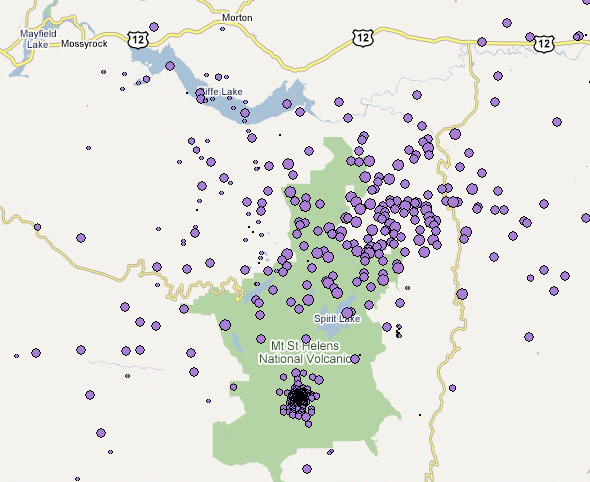
“Seismo-surfing” around the world can be quite interesting and fun. The following maps show the Mt. St. Helens Volcano in Washington, along with nicely co-located earthquake events (Figs 4 and 5).


How it Works
IEB is a Google Map mashup composed of a Google Map, HTML and Javascript code and an IRIS earthquake web-service. The web-service accesses several earthquake catalogs stored in the IRIS database. In total, the database contains around 2 million unique events dating from the early 1960s until present. To make the earthquake web-service fast, all events from the IRIS database are cached in memory on an IRIS server. Every 15 minutes the cache is synchronized with the IRIS earthquake database.
Javascript code in the IEB web page calls back to the Google web site to retrieve map information and calls back to the IRIS earthquake web-service to retrieve earthquake information. The earthquake information is returned in an XML format. With the advent of modern web-browsers this type of technology architecture is becoming increasingly common. It goes by the acronym AJAX which stands for Asynchronous JavaScript and XML. AJAX technology places a heavy burden on the user’s web browser. Recent versions of Firefox seem to work best. Microsoft Internet Explorer 6 and below are not supported.
The earthquake catalogs are provided by USGS/NEIC, ISC and the ANF.
Conclusion
The IEB is part of a new wave of web-service based technology being developed at the IRIS DMC. The IEB makes a large data set quickly and easily available. We would like to give special thanks to UNAVCO’s Stuart Weir for his help in integrating IEB data with the GEON IDV.
More information
Go to the IRIS Earthquake Browser
by Bruce Weertman (IRIS DMC) and Tim Knight (IRIS Data Management Center)


