Share and Preview Earth Models Using the EMC
The IRIS Earth Model Collaboration, EMC, is a long-term repository of Earth models with visualization tools for model preview and simple comparison. The Earth models are contributed by the research community. Access is provided to models in their original format and in a uniform netCDF format. Since its official launch in November 2011, the EMC has grown to contain 15 tomography models and 6 reference models. The models can be downloaded in either their original format or in netCDF format using IRIS’s Searchable Product Depository (SPUD).

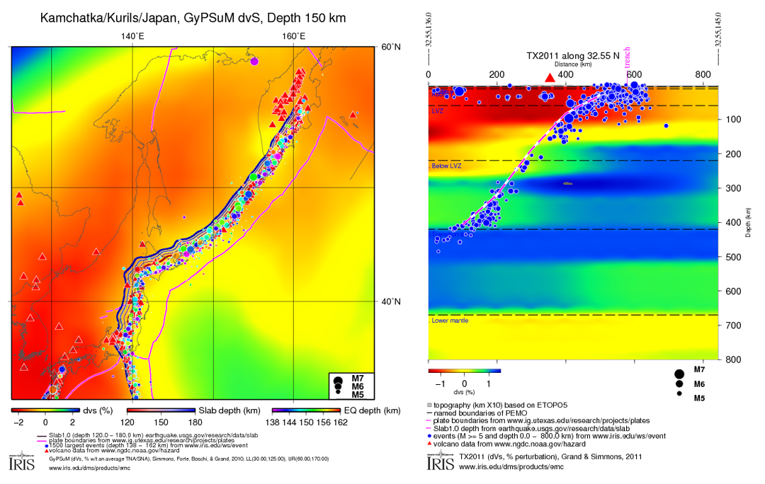
(Right) A cross section along latitude 32.55°N of the TX2011 model created using the Generalized X-section Viewer.
EMC’s visualization tools are based on the popular Generic Mapping Tools (GMT). In addition to allowing users to control the plot parameters, they are also provided with a copy of the GMT script and its corresponding data that could be used to reproduce the same plot in a more customized fashion. The EMC’s visualization tools include:
- A Horizontal Slice Viewer to plot a horizontal slice of selected Earth model at a given depth
- A Slice Stack Viewer to compare up to 4 horizontal slices by stacking them vertically
- A Cross-section Viewer to display a vertical slice through an Earth model
- A Cross-section Stack Viewer to display up to 4 parallel cross-sections
- A Velocity Trend Viewer to plot model velocity values (% perturbation) for a model, as a function of depth, at up to 4 locations (latitude-longitude pairs), and
- A Velocity-Depth Profile Viewer to plot model velocity values (km/s) as a function of depth for up to 4 locations (latitude-longitude pairs)
To add more value to the generated plots, the Horizontal Slice Viewer and the Cross-section Viewer visualization tools allow plotting the following auxiliary data on the generated map or section:
- The global Elevation ETOPO5 dataset
- NOAA volcano locations
- Earthquake locations from IRIS database
- Station locations from IRIS database
- Global CMT solutions from IRIS database
- Plate boundaries
- Measurements from the Géosciences Montpellier Shear-Wave Splitting Database
Researchers are encouraged to share their models through the EMC. For information on submitting a new model to the repository please refer to model contribution guidelines.
IRIS gratefully acknowledges Earth model contributions and review by the research community.
by Manoch Bahavar (IRIS Data Management Center) and Chad Trabant (IRIS DMC)


