Summary
A vertical shear wave speed (Vsv ) tomographic model of the upper mantle derived from the analysis of a large (∼1.2×10⁷ seismograms), multi-mode surface-wave data set has been used to construct a relationship between Vsv and temperature (T) for the shallower upper mantle (<300 km depth).
Quicklinks
Description
| Name | CAM2022 |
| Title | Global upper mantle surface wave tomography, temperature and LAB models |
| Type | 3-D Tomography Earth Model |
| Sub Type | S velocity, Temperature, LAB boundary |
| Year | 2024 |
| Data Revision | r0.0 (revision history) |
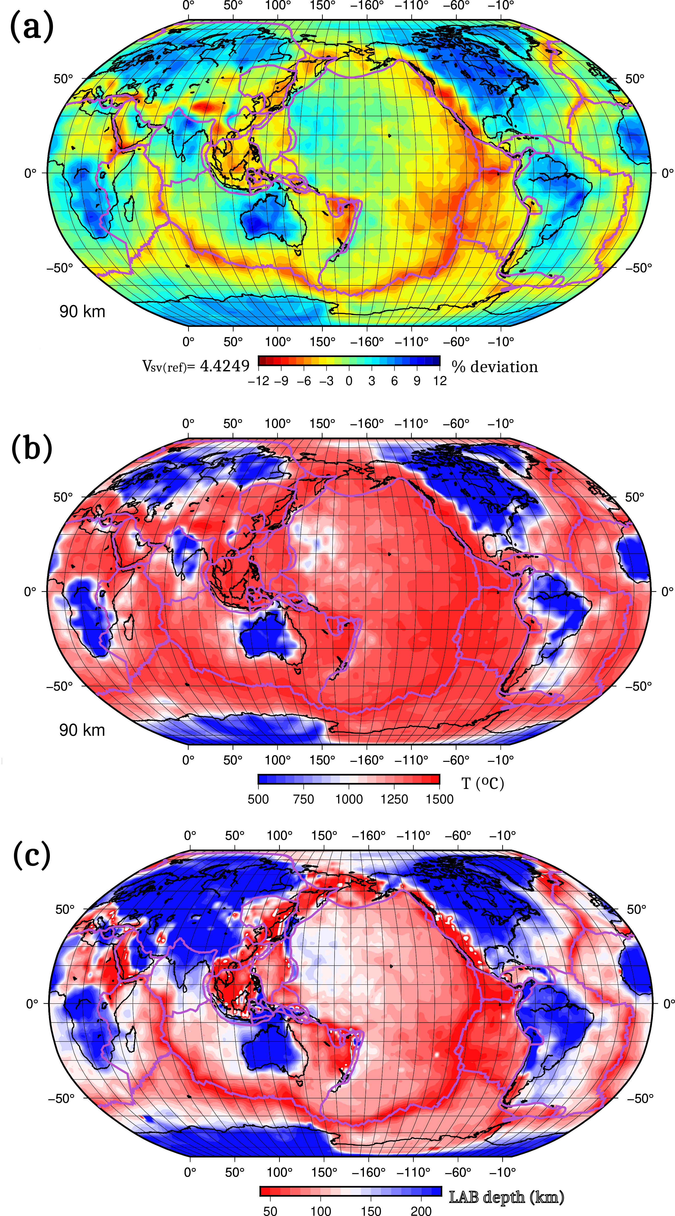
| Short Description | A vertical shear wave speed (Vsv ) tomographic model (e.g., Fig. 1a) of the upper mantle derived from the analysis of a large (∼1.2×10⁷ seismograms), multi-mode surface-wave data set has been used to construct a relationship between Vsv and temperature (T) for the shallower upper mantle (<300 km depth). This was accomplished by combining pressure (P) and T estimates from a model for the cooling oceanic lithosphere, P and T estimates from garnet peridotite nodules, and the estimated average potential temperature of the convecting upper mantle constrained by the thickness of the oceanic crust, with laboratory measurements of shear modulus and attenuation, to parameterize the dependence of Vsv on T and P (Priestley et al, 2024). The resulting parameters agree with those from independent laboratory measurements extending over a range of nine orders of magnitude of the dimensionless period. The Vsv(T) parameterization depends on the geophysical and geological observations and provides no detailed information on the physical processes involved. The fitting parameters are used to produce global estimates of the temperature at mantle depths shallower than 300 km (e.g., Fig. 1b) and from the resulting geotherm, deduce the thickness of the thermal lithosphere. The resulting lithospheric map (Fig. 1c) is similar to those of our previous studies (Priestley and McKenzie, 2006, 2013), although the use of the larger number of seismograms has considerably improved the resolution of the maps. Extensive regions of the continents are underlain by lithosphere whose thickness is less than that of old oceanic lithosphere. In contrast, the lithospheric thickness beneath most cratons is between 180 and 220 km. Where rifted continental margins formed when Pangea fragmented and cut across the cratonic lithosphere, the present continental margins coincide with the margins of the cratons. |
| Authors: | Keith Priestley, Bullard Laboratories, Department of Earth Sciences, University of Cambridge, Cambridge, United Kingdom |
| Previous Model | |
| Reference Model | reference.mod |
| Model Homepage | https://www.esc.cam.ac.uk/directory/keith-priestley |
| Model Download |
|
| Area | Global |
| Depth Coverage | Upper mantle (40 to 300 km) |
| Data Set Description | The Vsv, T and LAB models are derived from all waveforms with CMT solutions for the period 1976-2022 currently available at the IRIS and EIDA data centers, plus additional waveform data from Southern Asia sites. All models are defined on a 2 degree by 2 degree grid and the Vsv tomography model is derived with a smoothing half-length of 200 km. For the wave-speed model the absolute shear wave speed are tabulated, for the T model the temperatures in degrees C are tabulated and for the LAB model the depth of the themal LAB boundary in kms is tabulated. |

Citations and DOIs
To cite the original work behind this Earth model:
- Keith Priestley , Tak Ho, Yasuko Takei, Dan McKenzie, (2024), Earth Planet. Sci. Lett. 626 (2024), doi.org/
https://doi.org/10.1016/j.epsl.2023.118525 .
To cite IRIS DMC Data Products effort:
- Trabant, C., A. R. Hutko, M. Bahavar, R. Karstens, T. Ahern, and R. Aster (2012), Data Products at the IRIS DMC: Stepping Stones for Research and Other Applications, Seismological Research Letters, 83(5), 846–854, https://doi.org/10.1785/0220120032.
DOI for this EMC webpage: https://doi.org/10.17611/dp/emc.2024.cam2022.1
References
- Bird, 2003, An updated digital model of plate boundaries, Geochemistry, Geophysics and Geosystems, 4, 1027, https://doi.org/10.1029/2001GC000252
- Debayle and Sambridge, 2004, Inversion of massive surface wave data sets: Model construction and resolution assessment, J. Geophys. Res. Solid Earth, 109(B2), https://doi.org/10.1029/2003JB002652.
- Priestley and McKenzie, 2006, The thermal structure of the lithosphere from shear wave velocities, Earth and Planetary Science Letters, 244(1), 285–301, https://doi.org/10.1016/j.epsl.2006.01.008.
- Priestley and McKenzie, 2013, The relationship between shear wave velocity, temperature, attenuation and viscosity in the shallow part of the mantle, Earth and Planetary Science Letters 381, 78–91, https://doi.org/10.1016/j.epsl.2013.08.022.
- Priestley , Ho, Takei, McKenzie, 2024, Earth Planet. Sci. Lett. 626, https://doi.org/10.1016/j.epsl.2023.118525.
Credits
- r0.0 model provided by Keith Priestley.
Revision History
revision r0.0: uploaded March 6, 2024.
Timeline
- 2024-04-11
- r0.0 online


