Summary
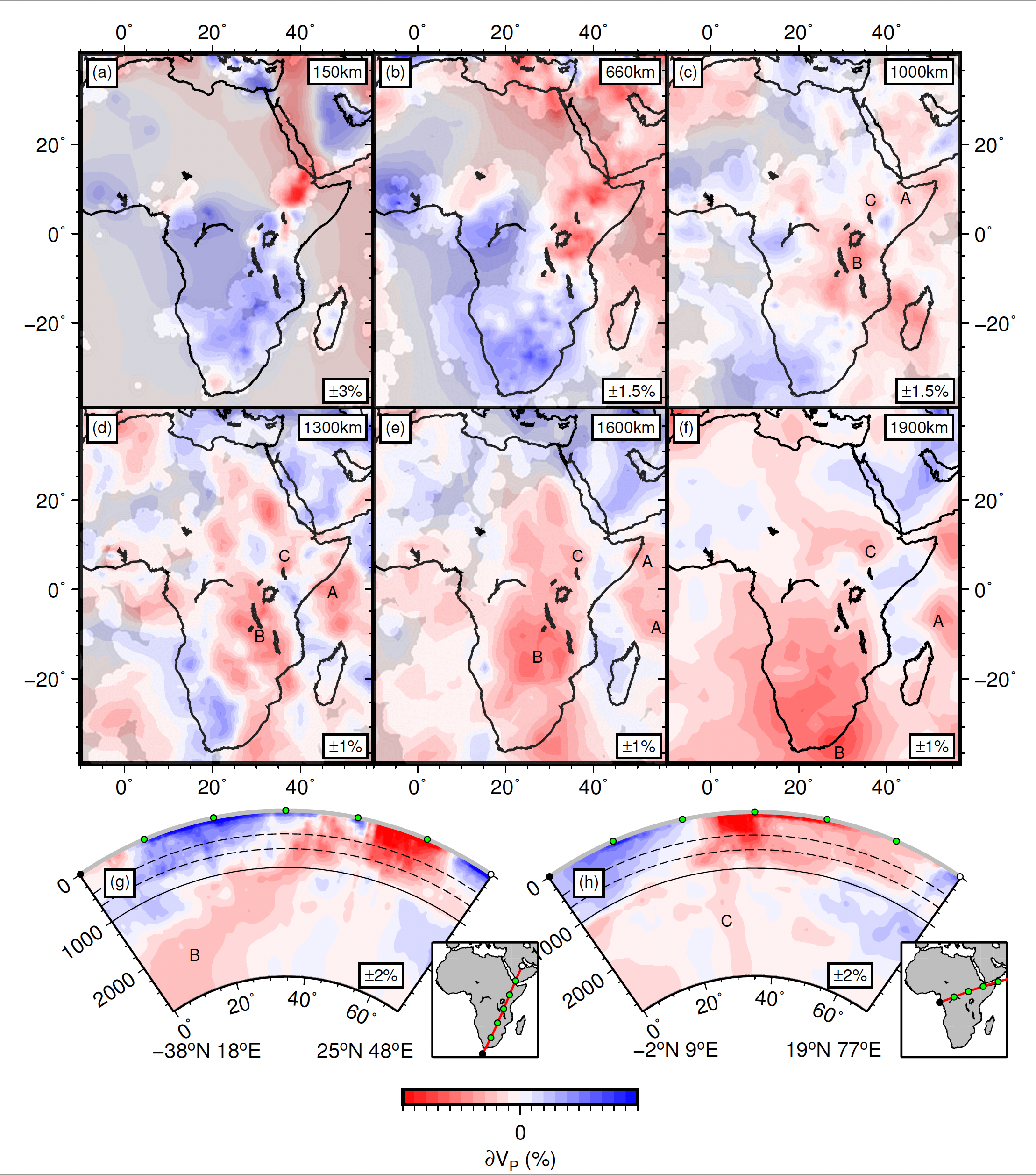
AFRP22 (Boyce et al., 2023), is an adaptively parameterized, absolute P-wave tomographic model for Africa provided with and without crustal correction.
Quicklinks
Description
| Name | AFRP22 |
| Title | An adaptively parameterized, absolute P-wave tomographic model for Africa provided with and without crustal correction. |
| Type | 3-D Tomography Earth Model |
| Sub Type | Absolute P-wave speed |
| Year | 2023 |
| Data Revision | r0.0 (revision history) |
| Short Description | AFRP22_RF_CR1_MOD is an adaptively parameterized, global absolute P-wave tomographic model following the methodology of Li et al., (2008). The crustal correction implemented in this model is described in the manuscript and supplementary material. ak135 (Kennett et al., 1995) is used as the global reference model. New data has been added in the Turkana Depression, Uganda, Mozambique and Namibia, so we provide only the African component of the model. While the adaptively parameterized grids at upper mantle depths can be found in the supplementary material of the manuscript, here we provide the model sampled at 0.25×0.25 degrees and 50km depth to facilitate smooth plotting. The 3D grid contains the columns: latitude (deg), longitude (deg), depth (km), dVp (percentage relative to ak135), vp (absolute vp in km/s). AFRP22_MOD is an identical tomographic model to that above but no crustal correction is implemented. Also available is a resolution/illumination mask for the upper part of the model (AFRP22_MASK). Regions with less favourable illumination are determined following the methodology of Boyce et al., (2021). The global data set will of course further illuminate the mantle wavespeed structure so this acts to show the areas better resolved using the new data. Regions where the mask is on (i.e. equal to 1) are regions of low confidence or poor resolution. Regions where the mask is off (i.e. equal to 0) are regions of high confidence or good resolution. Any values between these two extremes result from sampling the adaptively parameterized grid at 0.25×0.25 degree intervals to facilitate smooth plotting. The 3D grid contains the columns: latitude (deg), longitude (deg), depth (km), mask on (1/0). |
| Authors: | A. Boyce: University of Cambridge, Department of Earth Science, Bullard Laboratories, Madingley Road, Cambridge, UK. R. Kounoudis: Department of Earth Science and Engineering, Royal School of Mines, Prince Consort Road, Imperial College London, London, UK. I. D. Bastow: Department of Earth Science and Engineering, Royal School of Mines, Prince Consort Road, Imperial College London, London, UK. S. Cottaar: University of Cambridge, Department of Earth Science, Bullard Laboratories, Madingley Road, Cambridge, UK. C. J. Ebinger: Department of Earth and Environmental Sciences, Tulane University, New Orleans, LA 70118, USA. C. S. Ogden: School of Geography and Geology, University of Leicester, Leicester, LE1 7RH, UK. |
| Reference Model | ak135 |
| Model Page | https://alistairboyce11.github.io/ |
| Model Download | The original model files AFRP22_Original_distributable_model.tar.gz The above models in netCDF 3 Classic format. AFRP22-RF-CR1-MOD-3D.r0.0.nc (see metadata) AFRP22-MOD-3D.r0.0.nc (see metadata) AFRP22-MASK-3D.r0.0.nc (see metadata) |
| Depth Coverage | From 50 km to 2850 km |
| Area | Africa (latitude: -44° to 44°, longitude: -24° to 64°) |
| Data Set Description | Our global data set of absolute arrival-time picks includes P, Pn, Pg, pP, PKP, PKiKP and PKIKP phases from the “EHB” database (Engdahl et al., 1998), spanning the period 1964-2004 (Li et al., 2008). To constrain the African mantle, we use our previously published data set (Boyce et al., 2021). Here we improve resolution, especially in the Turkana Depression and Uganada, using newly available seismograph networks by adding >14,500 absolute arrival-times from P, PKP, PKiKP and PKIKP phases. Further details on analysis of these datasets can be found in the main manuscript. The raw data files, processed data, inversion software package and plotting codes will be available at https://doi.org/10.5281/zenodo.7607098 following removal of data embargo on 2024-05-24. |

Citations and DOIs
To cite the original work behind this Earth model:
- Boyce, A., Kounoudis, R., Bastow, I. D., Cottaar, S., Ebinger, C. J., & Ogden, C. S. (2023). Mantle wavespeed and discontinuity structure below East Africa: Implications for Cenozoic hotspot tectonism and the development of the Turkana Depression. Geochemistry, Geophysics, Geosystems, 24, e2022GC010775. https://doi.org/10.1029/2022GC010775
To cite IRIS DMC Data Products effort:
- Trabant, C., A. R. Hutko, M. Bahavar, R. Karstens, T. Ahern, and R. Aster (2012), Data Products at the IRIS DMC: Stepping Stones for Research and Other Applications, Seismological Research Letters, 83(5), 846–854, https://doi.org/10.1785/0220120032.
DOI for this EMC webpage: https://doi.org/10.17611/dp/emc.2023.afrp22.1
References
- Engdahl, et al., (1998). Global teleseismic earthquake relocation with improved travel times and procedures for depth determination. Bull. Seismol. Soc. Am. 88, 722–743.
- Kennett, et al., (1995). Constraints on seismic velocities in the earth from traveltimes. Geophys. J. Int. 122, 108–124. https://doi.org/
https://doi.org/10.1111/j.1365-246X.1995.tb03540.x .
- Li et al., (2008) A new global model for P wave speed variations in Earth’s mantle. Geochem. Geophys. Geosyst., 9, https://doi.org/
https://doi.org/10.1029/2007GC001806 .
- Boyce, A. Bastow, I.D. Cottaar, S. Kounoudis, R. Guilloud De Courbeville, J. Caunt, E. Desai, S. (2021), AFRP20: New P-wavespeed Model for the African Mantle Reveals Two Whole-Mantle Plumes Below East Africa and Neoproterozoic Modification of the Tanzania Craton, Geochem. Geophys. Geosyst., https://doi.org/
https://doi.org/10.1029/2020GC009302 .
Credits
- r0.0 model provided by Alistair Boyce.
Revision History
revision r0.0: uploaded February 8, 2023.
Timeline
- 2023-08-01
- r0.0 online


