About SPUD

SPUD Version 3.0

The Searchable Product Depository (SPUD) is the IRIS DMC's primary data product management system. Complementing the DMC's SEED and assembled data archives, which contain time series recordings, the SPUD system primarily contains derivative data products of other types (images, movies, etc.) created either at the DMC or by members of the community.

For users SPUD is the query and access point for these products. The web interfaces allow users to search for products using customized queries across product and event details. Users can search across all product types at once or within specific product types. SPUD also has web service interfaces for programmatic discovery and access to the data products.

If any products from SPUD are used in your research please be sure to cite the identified author of the product and the IRIS DMS [Citation Information].

About Ground Motion Visualization Products

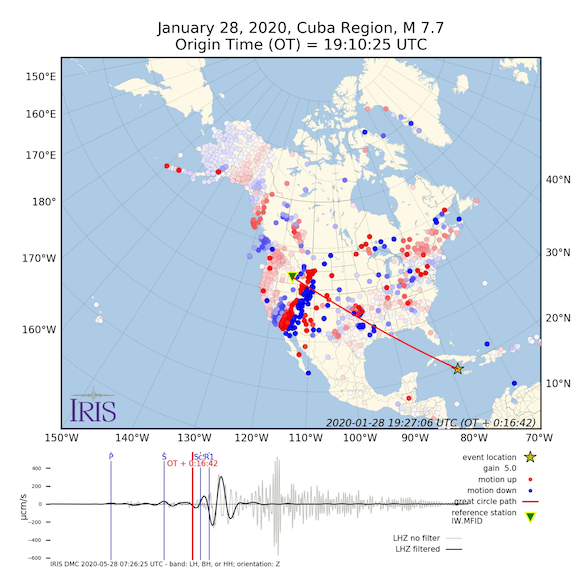
The Ground Motion Visualization (GMV) illustrates how seismic waves travel away from the earthquake location by depicting the recorded wave amplitudes at each seismic station location using colored symbols. For more information on GMVs visit the GMV product page.

Two types of GMVs are produced:

  • Vertical-component GMV:
    Produced for US events of magnitude 5.5 or larger and global events of magnitude 6 or larger. The symbol colors represent the amplitude of the vertical ground motion, as detected by the station's seismometer.
  • 3-Component GMV:
    Produced only for events with magnitude 7 and larger use 'tailed' symbols to show direction and amplitude of the normalized horizontal motion. Symbol colors also represent the amplitude of the vertical ground motion, as detected by the station's seismometer.

This product is automatically generated without human review.

GMV Query Help

This page queries for GMV products.

Citing Ground Motion Visualization Products

If you use GMVs in publications, please cite according to the instructions at:

http://ds.iris.edu/ds/products/gmv/#citation

Credits:

— Chuck Ammon, Professor of Geosciences at Penn State’s original concept and visualizations. Read more
— Bob Woodward at IRIS - adapted the visualization code to MATLAB

Download request too large

Requested download count exceeds maximum size (200) for this product.

GMV Product Query icon
Your session is about to expire!

Your session will expire in seconds.

Do you wish to continue?

Event Criteria
Depth (km)
0-33
33-70
70-150
150-300
300-500
500+
Magnitude
4
5
6
7
8
9
Max Lat:
Min Lon: Max Lon:
Min Lat:
Query Results: 3268 items found
ppPage: 1 of 33pp
Event Time (UTC)Depth (km)Trigger MagLatitudeLongitudeRegion
2023-06-08 20:31:457.1415.752.16177.76RAT ISLANDS, ALEUTIAN ISLANDS
2023-05-31 02:21:210.06.2-49.60163.92AUCKLAND ISLANDS, N.Z. REGION
2023-05-27 00:11:00223.9086.0-18.48-175.18TONGA ISLANDS
2023-05-26 10:03:2444.1756.235.62140.68NEAR EAST COAST OF HONSHU, JAPAN
2023-05-25 03:05:3310.06.68.89-77.12PANAMA-COLOMBIA BORDER REGION
2023-05-24 15:49:34166.4596.2-6.98129.53BANDA SEA
2023-05-23 06:41:5812.1436.1-23.00170.29SOUTHEAST OF LOYALTY ISLANDS
2023-05-21 18:44:0110.05.640.38-125.56OFF COAST OF NORTHERN CALIFORNIA
2023-05-21 15:45:1377.7916.1-10.27161.44SOLOMON ISLANDS
2023-05-21 14:56:4510.06.8-43.4439.37PRINCE EDWARD ISLANDS REGION
2023-05-20 02:09:5410.06.5-22.95170.48SOUTHEAST OF LOYALTY ISLANDS
2023-05-20 01:51:0135.9817.1-23.06170.46SOUTHEAST OF LOYALTY ISLANDS
2023-05-19 02:57:0637.7487.7-23.23170.69SOUTHEAST OF LOYALTY ISLANDS
2023-05-17 23:02:00252.06.415.15-90.84GUATEMALA
2023-05-10 16:02:00210.0977.6-15.60-174.61TONGA ISLANDS
2023-05-05 05:42:048.7126.237.54137.31NEAR WEST COAST OF HONSHU, JAPAN
2023-04-29 16:32:2677.06.256.21-156.69ALASKA PENINSULA
2023-04-28 03:13:51598.4676.6-25.27178.42SOUTH OF FIJI ISLANDS
2023-04-28 03:13:43576.7486.2-25.11178.46SOUTH OF FIJI ISLANDS
2023-04-24 20:00:5515.4627.1-0.7898.53SOUTHERN SUMATRA, INDONESIA
2023-04-24 00:41:5649.0357.1-29.95-177.84KERMADEC ISLANDS, NEW ZEALAND
2023-04-22 08:23:4744.1816.1-5.29125.58BANDA SEA
2023-04-19 09:06:0555.6746.3-6.00149.61NEW BRITAIN REGION, P.N.G.
2023-04-18 04:31:41562.4746.6-22.28179.39SOUTH OF FIJI ISLANDS
2023-04-14 09:55:45594.0287.0-6.03112.03JAVA, INDONESIA
2023-04-13 15:54:537.2756.049.21-129.62VANCOUVER ISLAND, CANADA REGION
2023-04-10 01:05:4810.06.0-3.51149.00BISMARCK SEA
2023-04-04 22:18:1212.9666.37.58-82.32SOUTH OF PANAMA
2023-04-04 12:54:3215.0276.213.75125.54PHILIPPINE ISLANDS REGION
2023-04-03 14:59:4284.5166.10.8998.84NORTHERN SUMATRA, INDONESIA
2023-04-03 03:06:57105.6316.552.78158.48NEAR EAST COAST OF KAMCHATKA
2023-04-02 18:04:1062.6037.0-4.29143.15NEW GUINEA, PAPUA NEW GUINEA
2023-03-30 17:33:0611.5866.3-35.66-73.54OFF COAST OF CENTRAL CHILE
2023-03-28 09:18:2730.9476.241.15142.80HOKKAIDO, JAPAN REGION
2023-03-27 22:19:1585.9766.1-8.21158.93SOLOMON ISLANDS
2023-03-22 16:00:31209.9766.5-23.48-66.51JUJUY PROVINCE, ARGENTINA
2023-03-21 16:47:23187.5896.536.5270.98HINDU KUSH REGION, AFGHANISTAN
2023-03-18 17:12:5266.4216.8-2.83-79.86NEAR COAST OF ECUADOR
2023-03-16 00:56:0222.0657.0-30.11-176.11KERMADEC ISLANDS REGION
2023-03-14 00:49:08213.06.3-5.41146.85EASTERN NEW GUINEA REG., P.N.G.
2023-03-07 13:51:4910.06.0-3.21150.65NEW IRELAND REGION, P.N.G.
2023-03-07 06:02:3438.6476.07.47126.03MINDANAO, PHILIPPINES
2023-03-04 06:41:22205.6816.9-29.47-178.79KERMADEC ISLANDS, NEW ZEALAND
2023-03-02 18:04:2910.06.5-15.41166.37VANUATU ISLANDS
2023-03-01 05:36:15598.9256.5-4.81149.49BISMARCK SEA
2023-02-25 21:24:4838.1586.2-6.11149.79NEW BRITAIN REGION, P.N.G.
2023-02-25 13:27:4242.8666.142.75145.13HOKKAIDO, JAPAN REGION
2023-02-23 20:02:4897.1456.33.32128.15NORTH OF HALMAHERA, INDONESIA
2023-02-23 00:37:4020.5226.838.0773.21TAJIKISTAN-XINJIANG BORDER REG.
2023-02-20 17:04:2916.06.336.1136.02JORDAN - SYRIA REGION
2023-02-17 09:37:3438.6156.1-6.60132.08TANIMBAR ISLANDS REG., INDONESIA
2023-02-15 18:10:1020.0886.112.32123.87LUZON, PHILIPPINES
2023-02-13 09:18:07374.0336.1-29.52-177.97KERMADEC ISLANDS, NEW ZEALAND
2023-02-06 12:02:1110.06.038.0636.54TURKEY
2023-02-06 10:26:4820.0946.038.0337.96TURKEY
2023-02-06 10:24:4910.07.538.0237.20TURKEY
2023-02-06 01:28:1312.236.737.1337.19TURKEY
2023-02-06 01:17:3517.9257.837.1737.03TURKEY
2023-02-01 10:44:4513.5016.07.78126.05MINDANAO, PHILIPPINES
2023-01-26 10:45:53135.6996.0-30.25-178.67KERMADEC ISLANDS, NEW ZEALAND
2023-01-24 18:37:00601.0246.4-26.69-63.17SANTIAGO DEL ESTERO PROV., ARG.
2023-01-20 22:09:39610.6716.8-26.72-63.04SANTIAGO DEL ESTERO PROV., ARG.
2023-01-20 11:23:41166.3726.216.13-62.16LEEWARD ISLANDS
2023-01-18 06:06:1347.9947.02.74127.05NORTHERN MOLUCCA SEA
2023-01-18 00:34:44152.5296.0-0.00123.18MINAHASSA PENINSULA, SULAWESI
2023-01-16 04:49:52409.0886.329.00139.35SOUTHEAST OF HONSHU, JAPAN
2023-01-15 22:29:5837.06.22.0098.01NORTHERN SUMATRA, INDONESIA
2023-01-11 16:17:4510.06.0-49.86-114.30SOUTHERN EAST PACIFIC RISE
2023-01-09 17:47:3495.1737.6-7.09130.04TANIMBAR ISLANDS REG., INDONESIA
2023-01-08 12:32:4227.7197.0-14.94166.88VANUATU ISLANDS
2022-12-28 16:34:2010.06.0-21.26171.36SOUTHEAST OF LOYALTY ISLANDS
2022-12-20 10:34:2516.066.3740.52-124.39NEAR COAST OF NORTHERN CALIF.
2022-12-14 18:40:2883.746.351.72178.65RAT ISLANDS, ALEUTIAN ISLANDS
2022-12-14 18:40:2673.06.351.62178.62RAT ISLANDS, ALEUTIAN ISLANDS
2022-12-11 14:31:2919.8066.017.22-100.47GUERRERO, MEXICO
2022-12-04 19:24:1535.9996.7-15.40-172.97SAMOA ISLANDS REGION
2022-11-23 01:08:1510.06.140.8530.97TURKEY
2022-11-22 16:39:0510.06.230.78-116.39BAJA CALIFORNIA, MEXICO
2022-11-22 02:37:5710.06.0-9.90159.53SOLOMON ISLANDS
2022-11-22 02:03:0715.07.0-9.81159.60SOLOMON ISLANDS
2022-11-21 15:09:3021.5265.552.36-168.20FOX ISLANDS, ALEUTIAN ISLANDS
2022-11-21 15:09:290.85.552.34-168.07FOX ISLANDS, ALEUTIAN ISLANDS
2022-11-18 13:37:0825.06.9-4.89100.80SOUTHWEST OF SUMATRA, INDONESIA
2022-11-14 08:08:26357.4416.133.80137.25NEAR S. COAST OF HONSHU, JAPAN
2022-11-14 05:04:11627.4276.1-26.04178.23SOUTH OF FIJI ISLANDS
2022-11-13 02:24:5718.06.2-37.46-73.74NEAR COAST OF CENTRAL CHILE
2022-11-12 07:09:14587.1897.0-20.12-178.36FIJI ISLANDS REGION
2022-11-11 10:48:4524.7977.3-19.32-172.10TONGA ISLANDS REGION
2022-11-09 10:14:33622.76.5-25.64178.42SOUTH OF FIJI ISLANDS
2022-11-09 09:51:04665.2677.0-26.04178.38SOUTH OF FIJI ISLANDS
2022-11-09 09:38:42628.9236.8-25.97178.36SOUTH OF FIJI ISLANDS
2022-11-09 09:38:41652.96.7-26.04178.58SOUTH OF FIJI ISLANDS
2022-11-04 10:02:4610.06.128.17-112.30GULF OF CALIFORNIA
2022-11-02 14:17:5110.06.1-60.80-25.73SOUTH SANDWICH ISLANDS REGION
2022-11-02 04:53:1210.06.031.42-133.30NORTH PACIFIC OCEAN
2022-10-25 14:59:0115.1776.417.66120.82LUZON, PHILIPPINES
2022-10-25 00:13:0281.7876.3-58.72-26.15SOUTH SANDWICH ISLANDS REGION
2022-10-20 11:57:1110.06.77.67-82.34SOUTH OF PANAMA
2022-10-16 12:48:2410.06.74.40-87.50OFF COAST OF CENTRAL AMERICA
2022-10-16 12:48:2110.06.34.38-87.51OFF COAST OF CENTRAL AMERICA
ppPage: 1 of 33pp