Summary
Alaska-S+SW-2018 is a 3D shear-wave velocity model of Alaskan upper mantle from the joint inversion of teleseismic S-wave travel-time residuals and Rayleigh wave dispersion.
Quicklinks
Description
| Name | Alaska-S+SW-2018 |
| Title | 3D shear-wave velocity model of Alaskan upper mantle from the joint inversion of teleseismic S-wave travel-time residuals and Rayleigh wave dispersion. |
| Type | 3-D Tomography Earth Model |
| Sub Type | Shear-wave velocity in perturbation (%). A regional average 1D model at 0-210 km depth (see Reference Model below) can be used to convert the model perturbation at such depths into absolute Vs. |
| Year | 2018 |
| Short Description | Teleseismic travel-time residuals and Rayleigh wave dispersion from the full EarthScope Transportable Array and more than 269 additional stations in Alaska and northwestern Canada are jointly inverted for 3-D velocity perturbations. |
| Authors: | |
| Chengxin Jiang | |
| Department of Earth and Planetary Sciences | |
| The University of New Mexico | |
| Brandon Schmandt | |
| Department of Earth and Planetary Sciences | |
| The University of New Mexico | |
| Kevin M. Ward | |
| Department of Geology and Geological Engineering | |
| South Dakota School of Mines & Technology | |
| Fan-Chi Lin | |
| Department of Geology and Geophysics | |
| The University of Utah | |
| Lindsay L. Worthington | |
| Department of Earth and Planetary Sciences | |
| The University of New Mexico | |
| Previous Model | None |
| Reference Model | Averaged 1D model is described as depth (km)-Vs(km/s): 5-3.142; 15-3.572; 25-3.701; 35-4.087; 45-4.328; 55-4.384; 65-4.410; 75-4.429; 90-4.446; 120-4.460; 150-4.482; 180-4.521; 210-4.579 |
| Model Download | Alaska-S+SW-2018_percent.nc (see metadata ), is the netCDF file for the model as a function of depth |
| Model Homepage | |
| Depth Coverage | 0 to 800 km |
| Area | Alaska and northwestern Canada (approx. 54°N/72°N latitude and 130°W/170W° longitude) |
| Data Set Description | [Jiang et al., 2018] The dataset includes 86652 multi-frequency S-wave travel time residuals and 8-100 s Rayleigh wave dispersion information. The Rayleigh wave dispersion at periods of 8-30 s are from Ward and Lin, [2018]. |

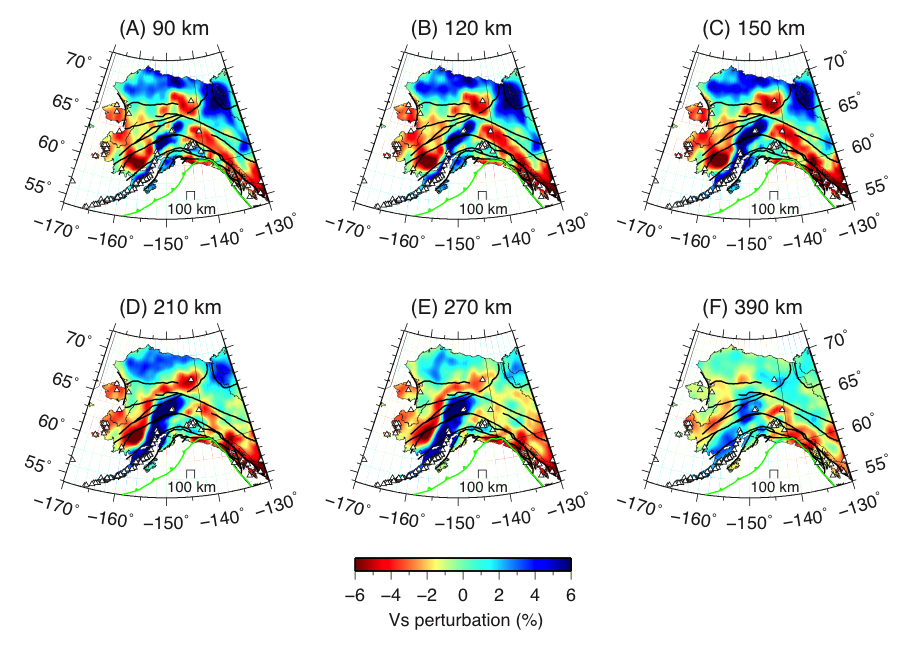
90 km. The black thin lines represent major faults, thick green line marks the Pacific plate
boundary, and white triangles denote <2 Ma volcanos. B) Shear-wave velocity at a depth of 120
km. C) Shear-wave velocity at a depth of 150 km. D) Shear-wave velocity at a depth of 210 km. E)
Shear-wave velocity at a depth of 270 km. F) Shear-wave velocity at a depth of 390 km.
Citations and DOIs
To cite the original work behind this Earth model:
- Jiang, C., Schmandt, B., Ward, K. M., Lin, F., and Worthington, L. L., (2018), Upper mantle seismic structure of Alaska from Rayleigh and S-wave tomography, Geophysical Research Letters, 45, 10350-10359. https://doi.org/10.1029/2018GL079406
To cite IRIS DMC Data Products effort:
- Trabant, C., A. R. Hutko, M. Bahavar, R. Karstens, T. Ahern, and R. Aster (2012), Data Products at the IRIS DMC: Stepping Stones for Research and Other Applications, Seismological Research Letters, 83(5), 846–854, https://doi.org/10.1785/0220120032.
DOI for this EMC webpage:
References
- Ward, K. M., and Lin, F., (2018), Lithospheric Structure Across the Alaskan Cordillera from the Joint Inversion of Surface Waves and Receiver Functions, Journal of Geophysical Research: Solid Earth, 123, 8780-8797. https://doi.org/10.1029/2018JB015967.
Credits
Model provided by Chengxin Jiang
Timeline
- 2018-10-02
- Added


