Summary
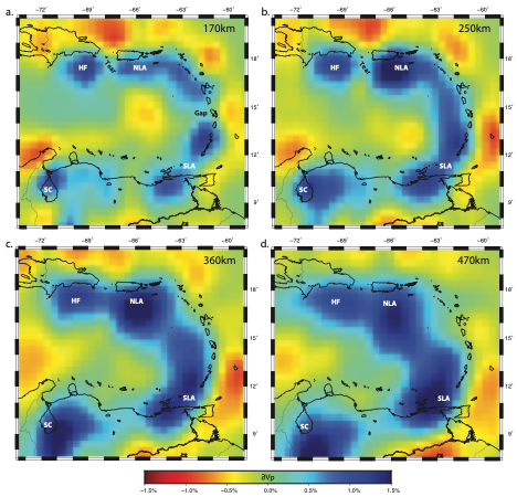
The Carib.Pwave.Harris.Miller.Porritt.2018 model incorporates broadband seismic data from 130 seismic stations deployed and maintained by multiple networks between 2000 to 2017. Data from 535 teleseismic earthquakes Mw>5.5 were to picked for P and PP to image the P wave velocity structure of the Caribbean mantle.
Quicklinks
Description
| Name | Carib.Pwave.Harris.Miller.Porritt.2018 |
| Title | 3D P-wave velocity model of the Caribbean mantle from teleseismic tomography |
| Type | 3-D Tomography Earth Model |
| Sub Type | P-wave velocity perturbation (%) |
| Year | 2018 |
| Data Revision | r0.0 (revision history) |
| Short Description | The model incorporates broadband seismic data from 130 seismic stations deployed and maintained by multiple networks between 2000 to 2017. Data from 535 teleseismic earthquakes Mw>5.5 were to picked for P and PP to image the P wave velocity structure of the Caribbean mantle. |
| Authors: | Cooper W. Harris, Department of Earth Sciences, University of Southern California, 3651 Trousdale Pkwy, Los Angeles, CA, 90039 USA Meghan S. Miller, Research School of Earth Sciences, The Australian National University, 142 Mills Rd Canberra, ACT, 2600 Australia Robert W. Porritt, Jackson School of Geosciences, The University of Texas, 23 San Jacinto Blvd Austin, TX, 78712, USA |
| Previous Model | N/A |
| Model Download | Harris-etal.2018-carib-dvp.r0.0.csv the originial model in GeoCSV format Harris-etal.2018-carib-dvp.r0.0.nc (see metadata) is the netCDF 3 Classic file for the model. |
| Depth Coverage | 0 km to 1000 km (bsl) |
| Area | Caribbean (latitude: 7.5°N/20.5°N, longitude: 286.5°E/301E°) |
| Data Set Description | [Harris et al., (2018)] The dataset includes the multi-frequency compression tomography model – relative P-wave velocity perturbations – for mantle structure beneath the Caribbean. The data used for the P wave model includes ~20,000 manually measured traveltime residuals, which reflect the difference between observed traveltimes and values predicted using the radially symmetric iasp91 global velocity model. 17,491 were measured from teleseismic P waves and 1,638 were measured from teleseismic PP waves. |

Citations and DOIs
To cite the original work behind this Earth model:
- Harris, C. W., Miller, M. S. & Porritt, R. W. (2018). Tomographic Imaging of Slab Segmentation and Deformation in the Greater Antilles, Geochemistry, Geophysics, Geosystems 19, 2292-2307. https://doi.org/10.1029/2018GC007603.
To cite IRIS DMC Data Products effort:
- Trabant, C., A. R. Hutko, M. Bahavar, R. Karstens, T. Ahern, and R. Aster (2012), Data Products at the IRIS DMC: Stepping Stones for Research and Other Applications, Seismological Research Letters, 83(5), 846–854, https://doi.org/10.1785/0220120032.
DOI for this EMC webpage: https://doi.org/10.17611/dp/emc.2021.caribpwave2018.1
Credits
- r0.0 model provided by Meghan Miller.
Revision History
revision r0.0: uploaded August 10, 2021.
Timeline
- 2021-08-13
- online


