Summary
iMUSH-MT is a three-dimensional electrical resistivity model for southwest Washington centered upon Mount St. Helens.
Quicklinks
Description
| Name | iMUSH-MT |
| Title | Imaging Magma Under St. Helens (iMUSH) 3D Electrical Resistivity Model |
| Type | 3-D Electrical Resistivity Earth Model |
| Sub Type | |
| Units | log10 electrical resistivity (Ohm-m) |
| Year | 2018 |
| Short Description | Three-dimensional electrical resistivity model for southwest Washington centered upon Mount St. Helens. |
| Authors: | |
| Paul A Bedrosian | |
| United Stated Geological Survey | |
| Denver, Colorado 80225, USA | |
| Jared R. Peacock | |
| United Stated Geological Survey | |
| Menlo Park, California 94025 | |
| Esteban Bowles-Martinez | |
| Oregon State University | |
| Corvallis, Oregon 97331, USA | |
| Adam Schultz | |
| Oregon State University | |
| Corvallis, Oregon 97331, USA | |
| Graham J. Hill | |
| University of Canterbury | |
| Chrustchurch 8041, New Zealand | |
| Previous Model | None |
| Reference Model | None |
| Model Download | iMUSH.MT.Bedrosian2018.resistivity.nc (see metadata ), is the netCDF file for the model and iMUSH-MT_Bedrosian_2018_resistivity_model.zip is the above model in its original format. |
| Model Homepage | None |
| Depth Coverage | 0 to 100 km |
| Area | Southwest Washington, United States (latitude: 45.09°/47.57°, longitude: -123.75°/-120.59°) |
| Data Set Description | Inversion used 295 MT stations (full impedance tensors and vertical magnetic field transfer functions, period range ~0.01-1000 s). |
| Supplemental Information |

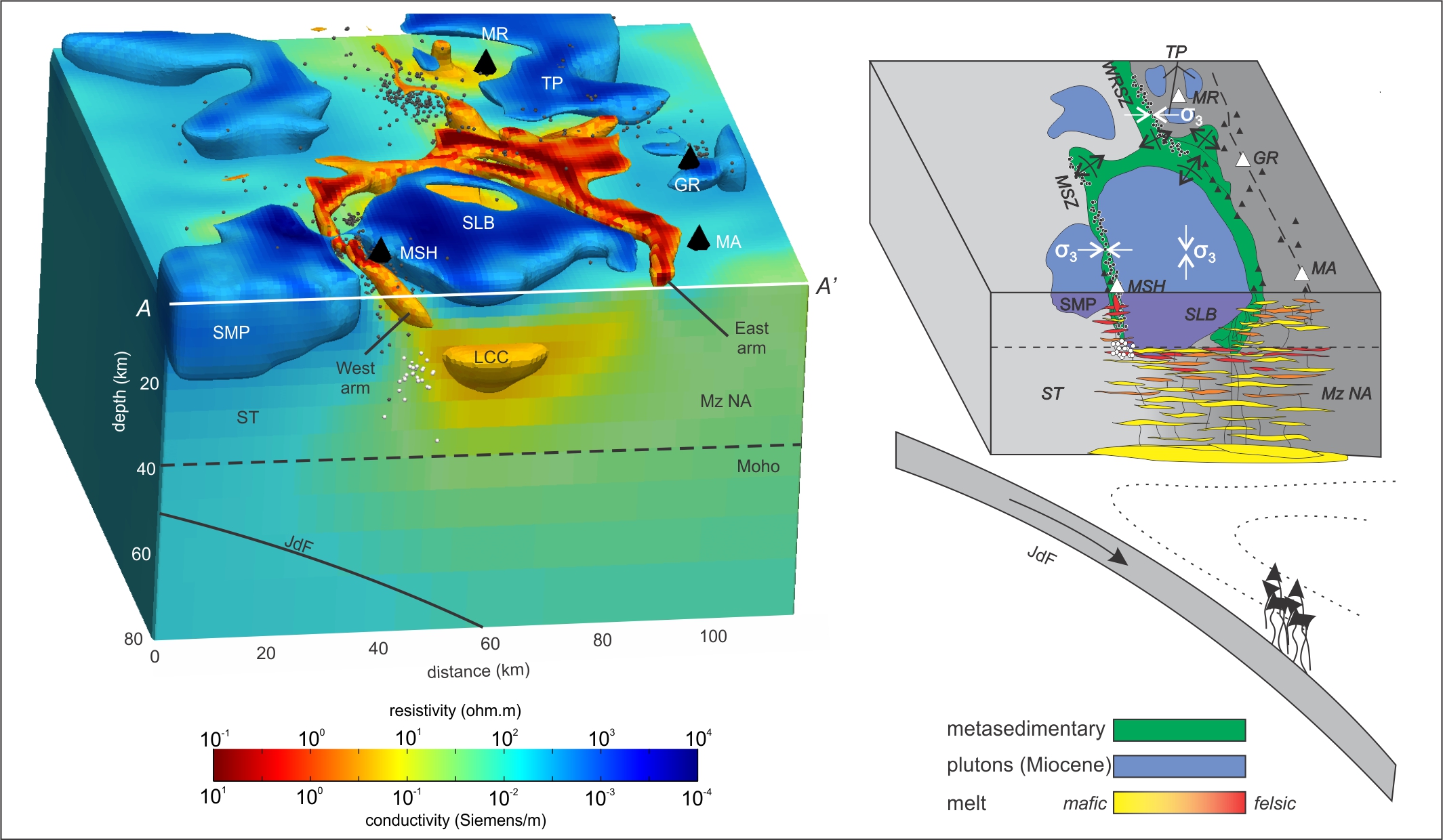
Isosurfaces are at resistivity greater than 300 Ω·m (blue) and less than 10 Ω·m (orange).
Seismicity shown in black; deep long-period earthquakes in white. Goat Rocks (GR);
Juan de Fuca (JdF); lower-crustal conductor (LCC); Mesozoic North America (MzNA); Mt.
Adams (MA); Mt. Rainier (MR); Mount St. Helens (MSH); Mount St Helens seismic zone (MSZ);
Siletz terrane (ST); Spirit Lake batholith (SLB); Spud Mountain pluton (SMP);
Tatoosh pluton (TP); West Rainier seismic zone (WRSZ). σ3 denotes interpreted minimum
principal stress direction (Bedrosian et al., Nature Geoscience, 2018).
Citations and DOIs
To cite the original work behind this Earth model:
- Bedrosian, P.A., Peacock, J.R., Bowles-Martinez, E. et al. Crustal inheritance and a top-down control on arc magmatism at Mount St Helens. Nature Geosci 11, 865–870 (2018). https://doi.org/10.1038/s41561-018-0217-2
To cite IRIS DMC Data Products effort:
- Trabant, C., A. R. Hutko, M. Bahavar, R. Karstens, T. Ahern, and R. Aster (2012), Data Products at the IRIS DMC: Stepping Stones for Research and Other Applications, Seismological Research Letters, 83(5), 846–854, https://doi.org/10.1785/0220120032.
DOI for this EMC webpage:
Credits
Model provided by Paul A Bedrosian
Timeline
- 2018-07-30
- online


