About SPUD

SPUD Version 3.0

The Searchable Product Depository (SPUD) is the IRIS DMC's primary data product management system. Complementing the DMC's SEED and assembled data archives, which contain time series recordings, the SPUD system primarily contains derivative data products of other types (images, movies, etc.) created either at the DMC or by members of the community.

For users SPUD is the query and access point for these products. The web interfaces allow users to search for products using customized queries across product and event details. Users can search across all product types at once or within specific product types. SPUD also has web service interfaces for programmatic discovery and access to the data products.

If any products from SPUD are used in your research please be sure to cite the identified author of the product and the IRIS DMS [Citation Information].

About Earth Model Products

The Earth models presented here are contributed to the IRIS Earth Model Collaboration (EMC) by various researchers.

Two general types of model are available for download:

  • Tomography Models:
    The contributed Earth models in their original format and in a common netCDF (network Common Data Form). A model overview page provides a summary of the model.

  • Reference Models:
    Most EMC Earth models are expressed as perturbations relative to a particular reference 1-D model. These reference models are available for download in expanded comma separated value (CSV) file format with the first two lines representing the file’s header.

For model visualization and additional information about the models visit the IRIS EMC Product Page.

Citing Earth Model Products

If you use Earth Models in publications, please cite according to the instructions at:

Ward, K. M., Porter, R. C., Zandt, G., Beck, S. L., Wagner, L. S., Minaya, E., and Tavera, H., 2014, Erratum: Ambient noise tomography across the central Andes: Geophysical Journal International, v. 196, p. 1264–1265, doi:10.1093/gji/ggt429.

Ward, K. M., Porter, R. C., Zandt, G., Beck, S. L., Wagner, L. S., Minaya, E., and Tavera, H., 2013, Ambient noise tomography across the central Andes: Geophysical Journal International, v. 194, p. 1559–1573, doi:10.1093/gji/ggt166.

http://ds.iris.edu/ds/products/emc/#citation

When citing this Earth Model page please use the Digital Object Identifier (DOI):

doi:10.17611/DP/10131299

Earth Model Help

The page displays information for individual Earth Models.

The model information is summarized at the top including links to further information.

3D shear-wave velocity model of the Central Andes from ambient noise tomography icon
Model Summary
Name:  Andes.ANT.Ward.2013
Title:  3D shear-wave velocity model of the Central Andes from ambient noise tomography
Type: 3D Tomography Earth Model
Sub Type:  Shear-wave velocity (km/s)
Year 2013
Author(s): Kevin M. Ward
Department of Geosciences
The University of Arizona
1040 E. 4th Street Tucson, AZ 85721, USA

George Zandt
Department of Geosciences
The University of Arizona
1040 E. 4th Street Tucson, AZ 85721, USA

Susan L. Beck
Department of Geosciences
The University of Arizona
1040 E. 4th Street Tucson, AZ 85721, USA

Ryan C. Porter
Department of Terrestrial Magnetism
Carnegie Institution of Washington
5241 Broad Branch Road, NW, Washington, DC 20015-1305, USA

Lara S. Wagner
Department of Geological Sciences
Calle Indaburo 944 Casilla 12656, La Paz, Bolivia

Estela Minayar
El Observatorio San Calixtor
University of North Carolina at Chapel Hillr
104 South Rd., Mitchell Hall, CB #3315, Chapel Hill, NC 27599-3315, USAr

Hernando Taverar
Instituto Geofisico Del Perur
Calle Badajo No. 169, Urb. Mayorazgo IV Etapa, Lima, Perur

Reference(s): Ward, K. M., Porter, R. C., Zandt, G., Beck, S. L., Wagner, L. S., Minaya, E., and Tavera, H., 2014, Erratum: Ambient noise tomography across the central Andes: Geophysical Journal International, v. 196, p. 1264–1265, doi:10.1093/gji/ggt429.

Ward, K. M., Porter, R. C., Zandt, G., Beck, S. L., Wagner, L. S., Minaya, E., and Tavera, H., 2013, Ambient noise tomography across the central Andes: Geophysical Journal International, v. 194, p. 1559–1573, doi:10.1093/gji/ggt166.
DOI: doi:10.17611/DP/10131299
Depth Coverage: -5.0 - 50.0 km
Areal Coverage: Latitude: -12.0 to -41.0 Longitude: -75.0 to -64.0
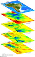
Model Description The model incorporates broadband seismic data from 20 seismic networks deployed incrementally in the Central Andes from 1994 May to 2012 August, to image the shear wave velocity structure of the South American Cordillera.
Data Set Description [Ward et al., (2013)] The dataset includes the absolute S-wave velocity structure across the Central Andes from ambient noise tomography.
EMC Page ds.iris.edu/ds/products/emc-andesantward2013
Model Data
DescriptionSizeModel
The netCDF binary for the above model expressed as S-wave velocity in km/s 8.8 MB
Model Areal Coverage
Contributions