Summary
A repository of Earth models with the aim of providing the research community with access to various Earth models, visualization tools for model preview, facilities to extract model data/metadata and access to the contributed processing software and scripts.
Quicklinks
Description

EMC serves as a repository of Earth models with the aim of providing the research community with access to various Earth models, visualization tools for model preview, facilities to extract model data/metadata and access to the contributed processing software and scripts.
The contributed Earth models are available for download from the model overview pages (see the Reference Models and Earth Models links below) or via EarthScope’s Searchable Product Depository (SPUD). Models could be downloaded in their original format and/or in a common netCDF (network Common Data Form) format that is compatible with all EMC visualization tools. The Earth model overview pages provide a summary of all contributed models and link to their metadata and description pages.
EMC Earth Model formats
- Format – netCDF-3 CLASSIC is the common container for all EMC models. netCDF-4 CLASSIC with compression is recommended for large models.
- Format conversion – A set of Python applications (EMC Tools) are available from the EarthScope’s GitHub repository to convert the Earth model files from netCDF 3 format to GeoCSV format, and vice versa.
- Projected and geographic coordinate systems – For information on EMC’s support for the projected coordinate systems, please see the EMC’s newsletter article on this subject.
- Grid-based and cell-based models – By default, in each 2D and 3D EMC Earth model, the model parameters (at a fixed depth for the 3D models) are single 2D variables that provide the model values at individual grid points. These models are grid-based models. On the other hand, in some models (such as CRUST1.0), the layer is broken into cells (tiles) with the coordinates referring to the center of the tiles. Therefore, in such models, the model parameter is evaluated at the cell center and is applied uniformly to the entire cell. Such models are cell-based models. To identify the cell-based models, a comment is added to the netCDF header indicating that the values are evaluated at the cell centers (see the CRUST1.0 metadata). Unless such a comment appears in the EMC model’s metadata, the model should be considered a grid-based model.
EMC Earth Model Links
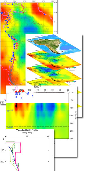
EMC also provides a set of Visualization Tools that are based on the Generic Mapping Tools (GMT) plotting package and allow users to produce a variety of horizontal slices, vertical slices and velocity profiles from the Earth models. Users can further refine these plots by clicking and downloading the corresponding visualization bundle.
EMC Visualization Tools
For additional information on EMC, including a guide on how to contribute Earth model to this repository, visit the EMC Reference Links below.:
EMC Reference Links
Citations and DOIs
To cite the IRIS DMC Data Products effort:
- Hutko, A. R., M. Bahavar, C. Trabant, R. T. Weekly, M. Van Fossen, T. Ahern (2017), Data Products at the IRIS‐DMC: Growth and Usage, Seismological Research Letters, 88, no. 3, https://doi.org/10.1785/0220160190.
- Trabant, C., A. R. Hutko, M. Bahavar, R. Karstens, T. Ahern, and R. Aster (2012), Data Products at the IRIS DMC: Stepping Stones for Research and Other Applications, Seismological Research Letters, 83(5), 846–854, https://doi.org/10.1785/0220120032.
To cite the IRIS Earth Model Collaboration (EMC) data product or reference use of its repository:
- IRIS DMC (2011), Data Services Products: EMC, A repository of Earth models, https://doi.org/10.17611/DP/EMC.1.
To cite the source or reference the use of a particular Earth model hosted by EMC:
- Please visit the specific Earth model’s page of interest and click on the Citations under Quicklinks.
Credits
- The research community for Earth model contributions and product review
- Manochehr Bahavar, IRIS DMC
Timeline
- 2011-11-14
- EMC online
- 2012-02-01
- Generalized X-section Viewer
- 2014-03-19
- Added supplemental information page option for the Earth Model
- 2015-06-13
- EMC 3D Visualizer released


