About SPUD

SPUD Version 3.0

The Searchable Product Depository (SPUD) is the IRIS DMC's primary data product management system. Complementing the DMC's SEED and assembled data archives, which contain time series recordings, the SPUD system primarily contains derivative data products of other types (images, movies, etc.) created either at the DMC or by members of the community.

For users SPUD is the query and access point for these products. The web interfaces allow users to search for products using customized queries across product and event details. Users can search across all product types at once or within specific product types. SPUD also has web service interfaces for programmatic discovery and access to the data products.

If any products from SPUD are used in your research please be sure to cite the identified author of the product and the IRIS DMS [Citation Information].

About Back Projections

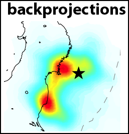
The Back Projection (BP) product shows the beamformed time history and location of coherent short period P-wave energy generated by large earthquakes observed at three regional arrays and across the Global Seismic Network. These are automatically generated following all global M6.5+ earthquakes.

Virtual networks are formed by choosing stations within 25 degrees distance or azimuth to the center of three continents (NAmerica, EUrope, AUstralia). All available BHZ data are then aligned using a Multi-Channel Cross Correlation scheme which also downsamples the network by only choosing the stations with the highest average cross-correlation coefficient and at least one degree distance to it's nearest neighboring stations. BPs are performed by beam forming energy using square-root stacking to a flat grid around the source region with variable spatial resolution scaled by the magnitude of the earthquake. A 5 s wide cosine taper is used to average the beams. BP results are then averaged over time windows whose length increases with magnitude.

The upper gallery shows a movie of the combined BPs from all networks with sufficient data. The array response function is also shown which is generated using the same processing techniques and stations, except the raw data are replaced with synthetic seismograms with 5 s wide point-source triangle functions. The first and last frames show cumulative time integrated results. Results are affected by radiation pattern, Greens functions variations and array geometry. Warmer colors indicate greater beam power. A small cross shows the location of the peak beam power when absolute beam powers are low.

The lower gallery shows a summary figure for each array's BP as well as the individual array movie. In the summary figure, the lower left panel shows the time and location of local maxima. The colors correspond to relative time and the diameter to relative beam power. The other panels show the time-integrated results, the source-receiver geometry, and the MCCC aligned traces.

At the bottom of the page, text files with peak beam power (and their Lat/Lon location) as a function of time relative to origin are given for both the data and the synthetic ARF.

For more information on Back Projections visit the Backprojection product page.

This product is automatically generated without human review.

Citing Back Projection Products

If you use Back Projections in publications, please cite according to the instructions at:

http://ds.iris.edu/ds/products/backprojection/#citation

When citing this Back Projections page please use the Digital Object Identifier (DOI):

doi:10.17611/DP/6690518

Back Projection Help

The page displays information for Back Projection data.

Back Projections for MI 8.0 NEAR COAST OF NORTHERN CHILE icon
Event
Date-Time (UTC): 2014-04-01 23:46:47
Location: NEAR COAST OF NORTHERN CHILE
Latitude, Longitude: -19.610 °, -70.769 °
Magnitude: 8.2 mww (us)
Depth: 25.0 km
Author: pt,at,us
Catalog, Contributor: NEIC PDE, us
Related Products:
Product Trigger Origin
Date-Time (UTC): 2014-04-01 23:46:45
Location: NEAR COAST OF NORTHERN CHILE
Latitude, Longitude: -19.630 °, -70.863 °
Magnitude: 8.0 MI (NEIC)
Depth: 10.0 km
Author: NEIC
Catalog, Contributor: NEIC PDE, NEIC ALERT


Product Download
Attachments
FilenameDescriptionFile Type
2014.04.01.23.46.BP.N.2.0.05to0.25Hz.GSN.PeakAmps.txtText file of peak backprojection amplitudes for GSNtext/plain
2014.04.01.23.46.BP.N.2.0.25to1.0Hz.EU.PeakAmps.txtText file of peak backprojection amplitudes for EUtext/plain
2014.04.01.23.46.BP.N.2.0.25to1.0Hz.NA.PeakAmps.txtText file of peak backprojection amplitudes for NAtext/plain
Contributions