| Name: |
LLNL-G3Dv3 |
| Title: |
A global P wave tomography model based on regional and teleseismic travel times |
| Type: |
3D Tomography |
| Sub Type: |
P velocity |
| Year |
2012 |
| Author(s): |
Nathan A. Simmons
Atmospheric, Earth and Energy Division
Lawrence Livermore National Laboratory
Livermore, California, USA
Stephen C. Myers
Atmospheric, Earth and Energy Division
Lawrence Livermore National Laboratory
Livermore, California USA
Gardar Johannesson
Systems and Decision Sciences
Lawrence Livermore National Laboratory
Livermore, California USA
Eric Matzel
Atmospheric, Earth and Energy Division
Lawrence Livermore National Laboratory
Livermore, California USA
|
| Reference(s): |
Simmons, N.A., S.C. Myers, G. Johannesson, and E. Matzel. 2012. "LLNL-G3Dv3: Global P wave tomography model for improved regional and teleseismic travel time prediction." J. Geophys. Res. 117:B10302, doi:10.1029/2012JB009525.
|
| DOI: |
doi:10.17611/DP/10131310 |
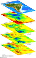
| Depth Coverage: |
0.0 - 2891.0 km |
| Areal Coverage: |
Latitude: -90.0 to 90.0 Longitude: -180.0 to 180.0 |
| Model Description |
The LLNL-G3Dv3 is a global-scale model of the crust and mantle P-wave velocity with regional-scale details. The model is parameterized using a spherical tessellation with node spacing of ~1 degree in the upper mantle and ~2 degrees in the lower mantle.
|
| Data Set Description |
The model was developed using over 2.8 million groomed and reprocessed P and Pn travel times with events located with the Bayesloc global multiple event location technique (Myers et al. 2007, 2009, 2011 ). Original data sources include the EHB bulletin (Engdahl et al., 1998 ) provided by the International Seismological Centre (ISC), the National Earthquake Information Center (NEIC) bulletin, and a variety of regional bulletins. Additional data are derived from seismic deployments for Peaceful Nuclear Explosions (PNE's), large refraction surveys, the USARRAY Transportable Array (TA) and temporary PASSCAL deployments around the world (IRIS).
|
| EMC Page |
ds.iris.edu/ds/products/emc-llnl-g3dv3/ |