| Name: |
TW-PS-H14 |
| Title: |
3D P-wave and S-wave velocity model of Taiwan from joint inversion of P-wave and S-wave travel times, strong motion S-P times, and borehole logging data. |
| Type: |
3D Tomography Earth Model |
| Sub Type: |
P-wave/S-wave velocity (km/s) and velocity perturbation (%), and Vp/Vs ratio |
| Year |
2014 |
| Author(s): |
Hsin-Hua Huang
Institute of Earth Sciences / Department of Geosciences
Academia Sinica / National Taiwan University
Taipei 115, Taiwan / Taipei 106, Taiwan
Yih-Min Wu
Department of Geosciences
National Taiwan University
Taipei 106, Taiwan
Xiaodong Song
Department of Geology
University of Illinois at Urbana-Champaign
Urbana, IL 61801, USA
Chien-Hsin Chang
Central Weather Bureau
Taipei 100, Taiwan
Shiann-Jong Lee
Institute of Earth Sciences
Academia Sinica
Taipei 115, Taiwan
Tao-Ming Chang
National Center for Research on Earthquake Engineering
Taipei 106, Taiwan
Hung-Hao Hsieh
National Center for Research on Earthquake Engineering
Taipei 106, Taiwan
|
| Reference(s): |
Huang, H.-H., Y.-M. Wu, X. Song, C.-H. Chang, S.-J. Lee, T.-M. Chang, and H.-H. Hsieh (2014), Joint Vp and Vs tomography of Taiwan: Implications for subduction-collision orogeny, Earth Planet. Sci. Lett., 392, 177-191, doi:10.1002/2014GL061115.
|
| DOI: |
doi:10.17611/DP/10131330 |
| Depth Coverage: |
-5.0 - 300.0 km |
| Areal Coverage: |
Latitude: 21.3 to 26.1 Longitude: 119.0 to 125.0 |
| Model Description |
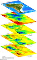
The 3-D perspective view of derived VS model, displaying the subduction-collision process along the plate boundary from south to north. EP: Euraisn Plate, PSP: Philippine Sea Plate, TCR: thickened crustal root, FAB: forearc basement. See the detail descriptions in Huang et al. (2014).
|
| Data Set Description |
[Huang et al. (2014)] Data set includes 7,587 local earthquakes, 1050 stations, and a total of 200,051 readings of P-wave, S-wave, and S-P times, as well as 1,780 P- and S-wave in situ logging data.
|
| EMC Page |
ds.iris.edu/ds/products/emc-tw-ps-h14 |