Summary
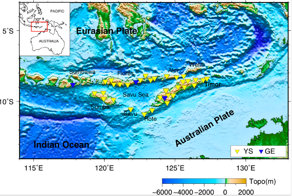
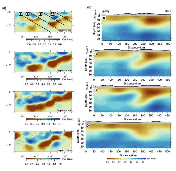
Banda_ANT_CrustVs_2020 is a 3-D crustal shear wave velocity model in the Banda Arc collision zone from ambient noise tomography with ~4-year data from 30 temporary broadband seismometers (YS array) deployed in the Nuna Tenggara Timur region of Indonesia and Timor-Leste, augmented by data of three permanent stations (GE network) in the region.
Quicklinks
Description
| Name | Banda_ANT_CrustVs_2020 | ||
| Title | A 3-D crustal shear wave velocity model in the Banda Arc collision zone from ambient noise tomography | ||
| Type | 3-D Tomography Earth Model | ||
| Sub Type | Shear wave velocity (km/s) | ||
| Year | 2020 | ||
| Data Revision | r0.0 (revision history) | ||
| Short Description | Banda_ANT_CrustVs_2020 is based on ambient noise tomography with ~4-year data from the Banda Arc passive seismic experiment consisting of 30 broadband instruments (YS array) in the Nuna Tenggara Timur region of Indonesia and Timor-Leste (latitude 7.5°S-11.25°S, longitude 117.5°E-128.5°E), augmented by data from three permanent seismic stations of the GE network in the region. | ||
| Authors: | Ping Zhang, Research School of Earth Sciences, Australian National University, Canberra, Australia Meghan S. Miller, Research School of Earth Sciences, Australian National University, Canberra, Australia |
||
| Previous Model | None | ||
| Reference Model | None | ||
| Model Download | Banda-ANT-CrustVs-2020.r0.0.nc (see metadata) in the Polar Stereographic Projection and in netCDF 3 Classic format. | ||
| Depth Coverage | 0 – 65 km (best resolution <50 km) | ||
| Area | Banda Arc (latitude: 7.5°-11.25° South and longitude is 117.5°-128.5° East) | ||
| Data Set Description | The 3-D Vs model in the crust and uppermost mantle is based on Rayleigh wave phase velocity dispersions (6-37 s) measured from continuous data from March 2014 to December 2018 (~4 years) recorded by 33 stations in the Banda Arc region and a 3-D surface wave direct inversion algorithm. Details are in Zhang and Miller, (2020). |
||
| Model Resolution Description; | Checkerboard tests with checker size of 0.75° by 0.75° show that the Vs model in upper 50 km can be reasonably resolved in regions where data coverage is dense with lateral resolution of ~60-80 km, although varying degrees of smearing are observed. Please refer to Zhang and Miller, (2020) for checkerboard test images and more details. |


Citations and DOIs
To cite the original work behind this Earth model:
- Zhang, P., and Miller, M.S., (2020) Seismic imaging of the subducted Australian Continental Margin beneath Timor and the Banda Arc collision zone, Accepted by GRL on November 24, 2020.
- Meghan S. Miller, Leland J. O’Driscoll, Nova Roosmawati, Cooper W. Harris, Robert W. Porritt, Sri Widiyantoro, Luis Teofilo da Costa, Eugenio Soares, Thorsten W. Becker, A. Joshua West; Banda Arc Experiment—Transitions in the Banda Arc‐Australian Continental Collision. Seismological Research Letters ; 87 (6): 1417–1423. https://doi.org/10.1785/0220160124
To cite IRIS DMC Data Products effort:
- Trabant, C., A. R. Hutko, M. Bahavar, R. Karstens, T. Ahern, and R. Aster (2012), Data Products at the IRIS DMC: Stepping Stones for Research and Other Applications, Seismological Research Letters, 83(5), 846–854, https://doi.org/10.1785/0220120032.
DOI for this EMC webpage: https://doi.org/10.17611/dp/emc.2020.bandaantcvs.1
Credits
- r0.0 model provided by Ping Zhang.
Revision History
revision r0.0: uploaded December 7, 2020.


