Summary
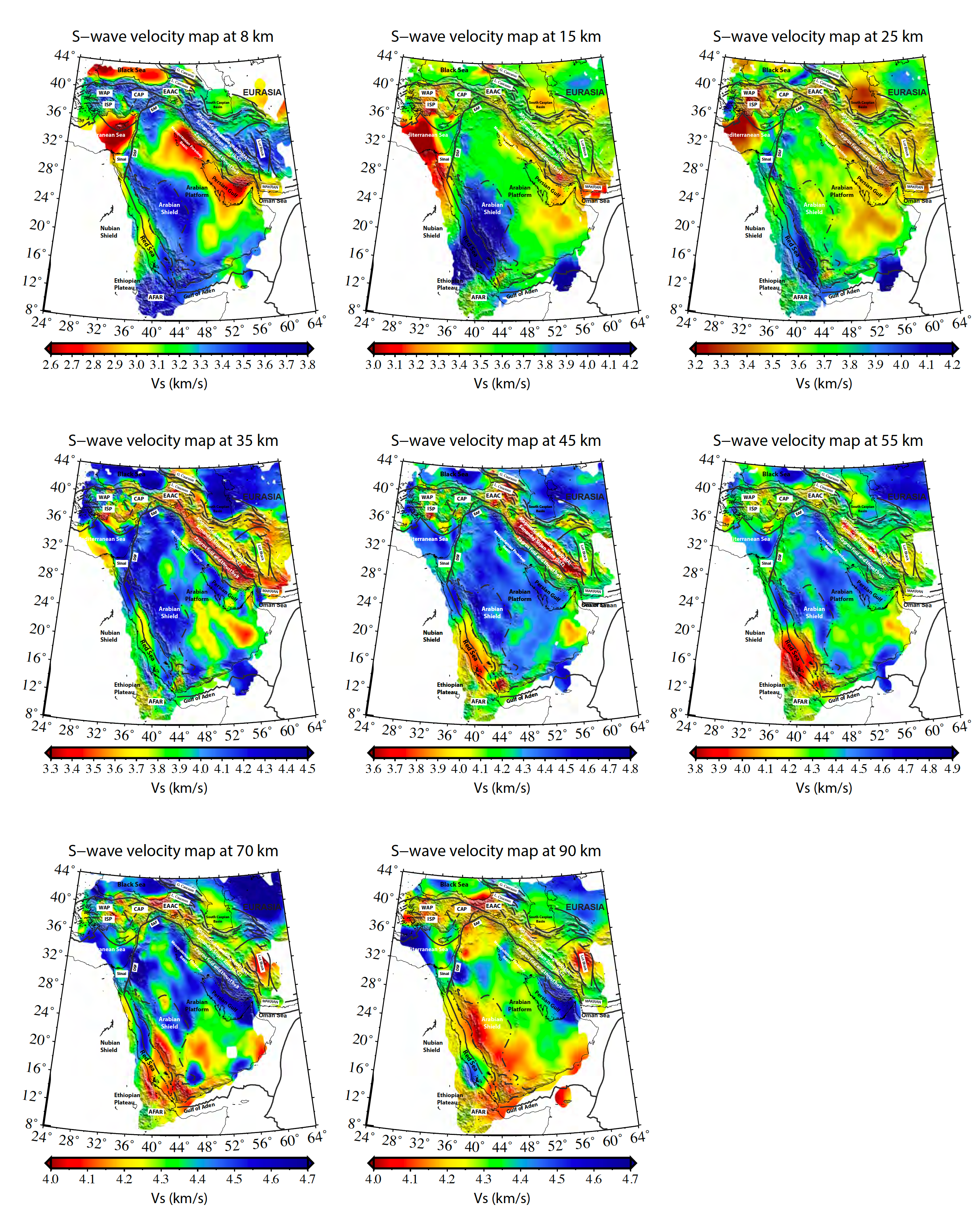
Midd_East_Crust_1 is a Regional crustal and uppermost mantle shear-wave velocity model for the Middle East.
Quicklinks
Description
| Name | Midd_East_Crust_1 |
| Version | 2020.02.04 |
| Title | Regional crustal and uppermost mantle shear-wave velocity model for the Middle East |
| Type | 3-D Tomography Earth Model |
| Sub Type | Absolute S-wave velocity (km/s) |
| Year | 2020 |
| Short Description | This model was constructed by inversion of Rayleigh wave dispersion curves obtained using ambient-noise cross-correlations and regional earthquakes from 852 permanent and temporary broadband stations in the Middle East. |
| Authors: | |
| Ayoub Kaviani, Institute of Geosciences, Goethe-University Frankfurt, Frankfurt/Main, Germany | |
| Anne Paul, Univ. Grenoble Alpes, Univ. Savoie Mont Blanc, CNRS, IRD, IFSTTAR, ISTerre, Grenoble 38041, France | |
| Ali Moradi, Institute of Geophysics, University of Tehran, Tehran, Iran | |
| Paul Martin Mai, Earth Science and Engineering Program, Physical Science and Engineering Division, King Abdullah University of Science and Technology (KAUST), Thuwal, Kingdom of Saudi Arabia | |
| Simone Pilia, Department of Earth Sciences, University of Cambridge, Cambridge, UK | |
| Lapo Boschi, Dipartimento di Geoscienze, Università degli Studi di Padova, Italy | |
| Georg Rümpker, Institute of Geosciences, Goethe-University Frankfurt, Frankfurt/Main, Germany | |
| Yang Lu,Univ. Grenoble Alpes, Univ. Savoie Mont Blanc, CNRS, IRD, IFSTTAR, ISTerre, Grenoble 38041, France | |
| Zheng Tang, Earth Science and Engineering Program, Physical Science and Engineering Division, King Abdullah University of Science and Technology (KAUST), Thuwal, Kingdom of Saudi Arabia | |
| Eric Sandvol, Department of Geological Sciences, University of Missouri-Columbia, USA | |
| Previous Model | None |
| Reference Model | None |
| Model Homepage | |
| Model Download | Midd_East-Crust-1.nc (see metadata ), is the netCDF file for the model |
| Depth Coverage | 0 to 105 km |
| Area | Broader region of the Middle East, including Iranian Plateau, Zagros, Turkish-Anatolian Plateau, the Caucasus, the Arabian Plate, Red Sea, Afar and eastern Mediterranean latitude: 8.0°/44.0° @0.25°, longitude: 24.0°/63.75° @0.25° |
| Data Set Description | The model uses group velocity dispersion curves obtained from ambient-noise cross-correlation and regional earthquakes for the 3-D shear-wave velocity structure of the curst and uppermost mantle beneath the Middle East. |
| Supplemental Information |

Citations and DOIs
To cite the original work behind this Earth model:
- Kaviani, A., Paul, A., Moradi, A., Mai, P. M., Pilia, S., Boschi, L., Rümpker, G., Lu, Y., Tang, Z., and Sandvol, E., 2020, Crustal and uppermost mantle shear-wave velocity structure beneath the Middle East from surface-wave tomography: Geophys. J. Int., https://doi.org/10.1093/gji/ggaa075.
To cite IRIS DMC Data Products effort:
- Trabant, C., A. R. Hutko, M. Bahavar, R. Karstens, T. Ahern, and R. Aster (2012), Data Products at the IRIS DMC: Stepping Stones for Research and Other Applications, Seismological Research Letters, 83(5), 846–854, https://doi.org/10.1785/0220120032.
DOI for this EMC webpage:
https://doi.org/10.17611/dp/emcmideastc120
Credits
- Model provided by Ayoub Kaviani
Timeline
- 2020-02-06
- online


