Summary
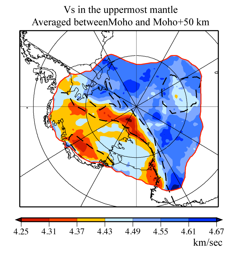
CWANT-PSP is a 3-D shear velocity model from a joint inversion of receiver functions and surface wave dispersion derived from ambient noise and teleseismic earthquakes.
Quicklinks
Description
| Name | CWANT-PSP |
| Title | Shear velocity structure of the crust and uppermost mantle beneath the central and West Antarctica |
| Type | 3D tomography |
| Sub Type | Shear wave speed (km/s) |
| Year | 2018 |
| Data Revision | r0.0 (revision history) |
| Short Description | This is a 3-D shear velocity model resulted from a Monte Carlo joint inversion of receiver functions and surface wave dispersion derived from both ambient noise and teleseismic earthquakes. The model covers central and West Antarctica (CWANT), an area that has been sampled by multiple seismic arrays (including the POLENET). The model was originally constructed beneath each of the 141 seismic stations (with joint inversion results) and 546 individual locations (with surface wave inversion alone), and then interpolated onto a 25 km * 25 km (approximately size) grid by simple kriging. The resulting model appears in the downloadable file that includes a directory MOD_0.25, separately as a set of 2-D maps for each depth (spaced 1 km vertically). The description of the model can be found in Shen et al. (2018) |
| Usage Notes | This model is in Antarctic Polar Stereographic projection with latitude of true scale at at the pole (-90°, 0°); the origin (0,0) km at South Pole; Positive Y-axis along 0 degree longitude; Positive X-axis along 90 degree East longitude. See CWANT.PSP.r0.0.nc metadata for projection parameters. |
| Authors: | Weisen Shen: Department of Geosciences, Stony Brook University, Stony Brook, NY, USA Douglas A. Wiens: Department of Earth and Planetary Sciences, Washington University, St. Louis, MO, USA Andrew J. Lloyd: Lamont-Doherty Earth Observatory, Columbia University, Palisades NY, USA Andrew A. Nyblade: Department of Geosciences, Pennsylvania State University, PA, USA Richard C. Aster: Department of Geosciences, Colorado State University, Fort Collins, CO, USA Samantha E. Hansen: Department of Geological Sciences, The University of Alabama, Tuscaloosa, AL, USA Ian W. D. Dalziel: Institute for Geophysics, Jackson School of Geosciences, The University of Texas at Austin, Austin, TX, USA Terry J. Wilson: Byrd Polar Research Center and School of Earth Sciences, The Ohio State University, Columbus, OH, USA Sridhar Anandakrishnan: Department of Geosciences, Pennsylvania State University, PA, USA Peter Gerstoft: Scripps Institution of Oceanography, University of California, San Diego, CA, USA Peter D. Bromirski: Scripps Institution of Oceanography, University of California, San Diego, CA, USA David S. Heeszel: U.S. Nuclear Regulatory Commission, Washington, DC, USA Andrey D. Huerta: Department of Geological Sciences, Central Washington University, Ellensburg, WA, USA Ralph Stephen: Woods Hole Oceanographic Institution, Woods Hole, MA, USA J. Paul Winberry: Department of Geological Sciences, Central Washington University, Ellensburg, WA, USA |
| Previous Model | None |
| Reference Model | None |
| Model Download | CWANT.PSP.r0.0.nc (see metadata) in the Polar Stereographic Projection and in netCDF 3 Classic format. CWANT.PSP_Model.tar in geographic coordinate and txt format. |
| Model Homepage | |
| Depth Coverage | The model covers a depth range from 0 to 150 km depth relative to the surface of the solid earth (bottom of the ice-sheet or ocean) |
| Area | The model covers a region that spans the central and West Antarctica |
| Data Set Description | The Monte Carlo inversion (Shen et al., 2013) is performed to a combination of receiver functions, ambient noise-derived and teleseismic earthquake-derived surface wave maps. The ambient noise data is collected between 2001-2015 on 219 stations. Receiver functions are collected at 144 stations, from seismic events with 30-120deg distance (Mb>5.5). For teleseismic surface wave tomography, only Rayleigh wave alone is performed using a finite frequency method (2-plane wave tomography (2PWT), Forsyth and Li, 2005) between 26 and 143 s. For ambient noise tomography, ray-theory based tomography is applied to 8-50 s period band, and both phase and group velocity dispersions are obtained. |

Citations and DOIs
To cite the original work behind this Earth model:
- Shen, W., Wiens, D. A., Anandakrishnan, S., Aster, R. C., Gerstoft, P., Bromirski, P. D., et al. (2018). The crust and upper mantle structure of central and West Antarctica from Bayesian inversion of Rayleigh wave and receiver functions. Journal of Geophysical Research: Solid Earth, 123, 7824– 7849. https://doi.org/10.1029/2017JB015346
To cite IRIS DMC Data Products effort:
- Trabant, C., A. R. Hutko, M. Bahavar, R. Karstens, T. Ahern, and R. Aster (2012), Data Products at the IRIS DMC: Stepping Stones for Research and Other Applications, Seismological Research Letters, 83(5), 846–854, https://doi.org/10.1785/0220120032.
DOI for this EMC webpage: https://doi.org/10.17611/dp/emc.2020.cwantpsp.1
References
- Forsyth, D.W. and Li, A. (2005). Array Analysis of Two‐Dimensional Variations in Surface Wave Phase Velocity and Azimuthal Anisotropy in the Presence of Multipathing Interference. In Seismic Earth: Array Analysis of Broadband Seismograms (eds A. Levander and G. Nolet). https://doi.org/10.1029/157GM06
- Weisen Shen, Michael H. Ritzwoller, Vera Schulte-Pelkum, Fan-Chi Lin, Joint inversion of surface wave dispersion and receiver functions: a Bayesian Monte-Carlo approach, Geophysical Journal International, Volume 192, Issue 2, February 2013, Pages 807–836, https://doi.org/10.1093/gji/ggs050
Credits
- r0.0 model provided by Weisen Shen.
Revision History
revision r0.0: uploaded November 17, 2020.
Timeline
- 2020-11-20
- online


