Summary
SEMum_NA14 North American regional shear velocity model is an isotropic and radially anisotropic Vs model for the North American upper mantle which took advantage of the USArray TA deployment (Yuan et al., 2014). The model is developed using long period 3-component fundamental and overtone surface waveforms in the frame work of a hybrid inversion scheme (Lekić and Romanowicz, 2011), using Spectral Element Method (RegSEM, Cupillard et al., 2012)for accurate waveform computation in the forward simulation, and Non-linear normal Mode Asymptotic Coupling Theory (Li and Romanowicz, 1995;1996) for the inverse problem.
Quicklinks
Description
| Name | SEMum_NA14 |
| Title | A high-resolution North American shear velocity model of upper mantle |
| Type | 3-D full-waveform Earth Model |
| Sub Type | An isotropic and radially anisotropic shear velocity model |
| Year | 2014 |
| Short Description | SEMum_NA14 is a radially anisotropic shear velocity model, parameterized in terms of isotropic S velocity (Voigt average), and the radial anisotropic parameter, xi (V sh 2 /V sv 2 ). (see Reference Model below). |
| Authors: | |
| Huaiyu Yuan | |
| Berkeley Seismological Laboratory (Now at Macquarie University, North Ryde, Australia huaiyu.yuan@gmail.com ) | |
| University of California, Berkeley | |
| Barbara Romanowicz | |
| Berkeley Seismological Laboratory | |
| University of California, Berkeley |
| Previous Model | SAWum_NA2 |
| Reference Model | A modified version of that used in SEMum2 model(French and Romanowicz, 2014): A smooth, modified version of PREM , with the Q structure of QL6 (Durek and Ekstrom, 1996) that fits normal mode frequencies. |
| Model Download | |
| Please follow the model home page for model downloading in ASCII format: http://seismo.berkeley.edu/wiki_br/Regional.vectorial.tomography.2 | |
| SEMum-NA14_kmps.nc (see metadata ), is the netCDF file for the model | |
| Model Homepage | http://seismo.berkeley.edu/wiki_br/Regional.vectorial.tomography.2 |
| Depth Coverage | 50 to 410 km |
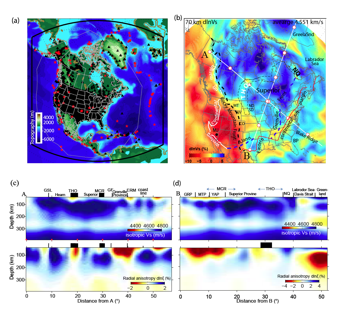
| Area | North America (10° to 80° latitude and 180° to 330° longitude); see Figure (a) below defining the model space. |
| Data Set Description | 60s Long-period 3-component waveforms (fundamental mode and overtones) from 360 global events recorded on the global network used in Lekic and Romanowicz 2012; ~600 global events recorded at North American stations; and 40s waveforms from 136 local events (in Figure (a) below). |

(B) 3D isotropic shear wave velocity structure at 70km, shown as variations with respect to the regional mean (See Fig 2 in Yuan et al, 2014 for details). Locations of two depth cross-sections shown in© and (d) are indicated. Red dots indicate 10° distance mark on the x-axis along each transect. See Yuan et al., 2014 for details geological features and locations.
(C) Depth cross-section of isotropic Vs (top subpanel) and radial anisotropy variation (bottom subpanel) for Profile A. Features marked are: GSL, Great Slave Lake suture zone; THO, Trans-Hudson Orogen; MCR, Mid-continent Rift; GF, Grenville deformation Front; ERM, eastern continental rift margin. Coastline is indicated. Note the correlation of negative ξ anomaly under all sutures.
(D) Same as© but for Profile B. GRP, Granite-Rhyolite Province; MTP, Mazatzal Province; YAP, Yavapai Province; MCR, Mid-continent Rift; THO, Trans-Hudson Orogen; and NQ, New Quebec Orogen.
Citations and DOIs
To cite the original work behind this Earth model:
- Yuan, H., French, S., Cupillard, P., Romanowicz, B., 2014. Lithospheric expression of geological units in central and eastern North America from full waveform tomography. Earth Planet Sc Lett. 402, 176–186, https://doi.org/10.1016/j.epsl.2013.11.057.
To cite IRIS DMC Data Products effort:
- Trabant, C., A. R. Hutko, M. Bahavar, R. Karstens, T. Ahern, and R. Aster (2012), Data Products at the IRIS DMC: Stepping Stones for Research and Other Applications, Seismological Research Letters, 83(5), 846–854, https://doi.org/10.1785/0220120032.
DOI for this EMC webpage:
References
- Cupillard Cupillard, P., Delavaud, E., Burgos, G., Festa, G., Vilotte, J.-P., Capdeville, Y., Montagner, J.-P., 2012. RegSEM: a versatile code based on the spectral element method to compute seismic wave propagation at the regional scale. Geophys. J. Int. 188, 1203-1220.
- French, S.W., Romanowicz, B.A., 2014. Whole-mantle radially anisotropic shear velocity structure from spectral-element waveform tomography. Geophys. J. Int. 199, 1303-1327.
- Lekić, V., Romanowicz, B., 2011. Inferring upper-mantle structure by full waveform tomography with the spectral element method. Geophys. J. Int. 185, 799-831.
- Li, X., Romanowicz, B., 1996. Global mantle shear velocity model developed using nonlinear asymptotic coupling theory. J. Geophys. Res 101, 22245-22273.
- Li, X.-D., Romanowicz, B., 1995. Comparison of global waveform inversions with and without considering cross-branch modal coupling. Geophys. J. Int. 121, 695-709.
- Montagner, J.-P., Griot-Pommera, D.-A., Lave, J., 2000. How to relate body wave and surface wave anisotropy? J. Geophys. Res. 105, 19,015-019,027.
- Romanowicz, B., Yuan, H., 2012. On the interpretation of SKS splitting measurements in the presence of several layers of anisotropy. Geophys. J. Int. 188, 1129-1140.
- Yuan, H., French, S., Cupillard, P., Romanowicz, B., 2014. Lithospheric expression of geological units in central and eastern North America from full waveform tomography. Earth Planet Sc Lett. 402, 176–186.
Credits
Model provided by Huaiyu Yuan
Timeline
- 2017-02-09
- online


